For my recent trip to Madagascar I equipped myself with a netbook, TransDEM and the Soviet topographic maps 1:200,000, possibly still the best maps you can get for that region. I also took my reliable Garmin GPS device and loaded it with Open Street Map data. OSM coverage of Madagascar, however, is sparse. Outside of towns you'll get the major road and nothing else. Google has a bit more, but Google is proprietary data, no way to use it with Garmin units.
The problem I encountered was to bring GPS and the Soviet maps in sync while riding the train or the bus. I manually transferred coordinates between the Garmin and TransDEM but this seemed somewhat cumbersome. So, having returned home now, I went for improvement: Adding a GPS live feed function to TransDEM.
There is a handy protocol for this: NMEA0183. It's a bit dated and requires a serial RS232 interface, but it's supported by many GPS devices. However, these days neither netbooks or laptops offer a serial COM interface. And some GPS devices don't have RS232 either. Many have USB only. Fortunately, there is 3rd party software to translate from USB to virtual COM.
Last weekend I implemented the basic functionality for GPS tracking into TransDEM and successfully connected my GPSMap60CSx to it. The GPS units usually send the current fix (position) once a second over NMEA0183 and TransDEM will draw the series of fixes as a polyline, like you would do manually with the built-in Simple Route Editor. TransDEM will also offer to save such tracklogs as ordinary vector data.
Live GPS Tracking
Re: Live GPS Tracking
G'day geophil,
I hope you realise the 'potential' for this 'innovation', Roland?...
Jerker {:)}
I hope you realise the 'potential' for this 'innovation', Roland?...
Jerker {:)}
Re: Live GPS Tracking
You mean outside Trainz? I am aware that most mapping software for the outdoor activity market supports this feature. As mobile PC systems become smaller and handier, e.g. netbooks, with increased battery lifetime, it becomes less of a hassle to bring them along and actually make use of them on a trip. Even slate-type machines, once they run Windows, could become useful.
I am also thinking about the other way round, uploading raster maps to GPS devices, Garmin in particular. Newer Garmin models support raster maps with georeference information embedded into a Google Earth kmz file. However, you will need a fairly large display on the GPS unit to benefit from this.
I am also thinking about the other way round, uploading raster maps to GPS devices, Garmin in particular. Newer Garmin models support raster maps with georeference information embedded into a Google Earth kmz file. However, you will need a fairly large display on the GPS unit to benefit from this.
Re: Live GPS Tracking
G'day geophil,
...well, that's a few uses you could put it to but I had in mind the one that would allow you to 'ride' or walk along your prospective 'line' and subsequently obtain an EXACT location of the route in the geography, rather than having to rely on someone else's 'work' or working from maps that can be notoriously incorrectly georeferenced, so that one would actually get a Route Polyline that is "spot on"...
Jerker {:)}
Re: Live GPS Tracking
Alpha test.
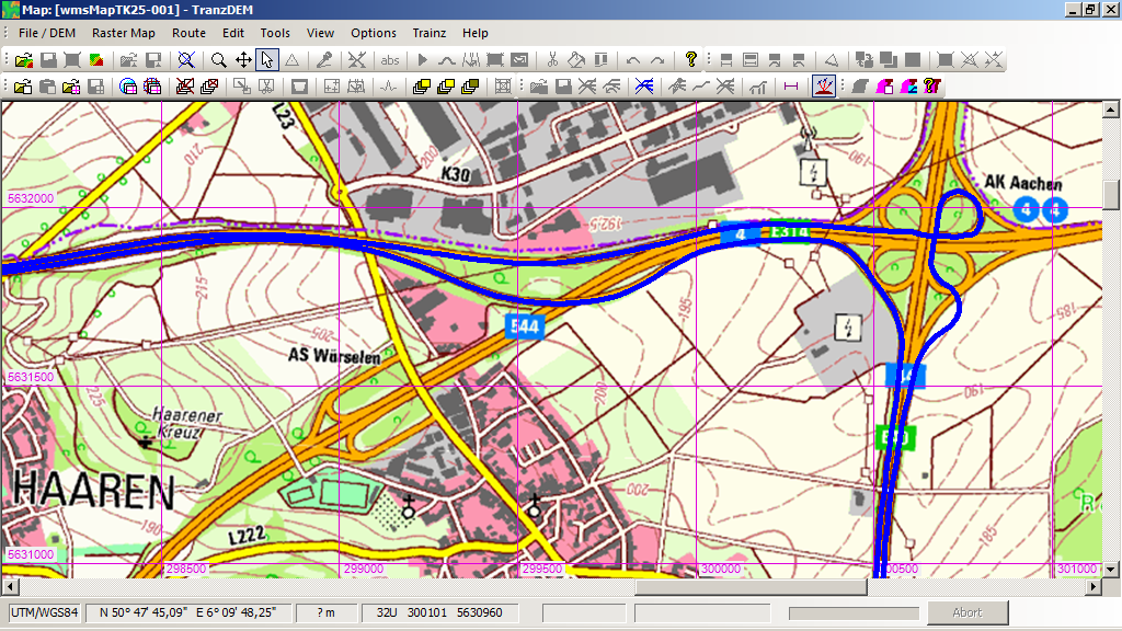
Installed a freshly built TransDEM exe on my netbook, placed the netbook into my car, connected my hand-held Garmin GPS to it via USB, acitivated the new GPS track log feature in TransDEM and started driving.
To gap the bridge between the Garmin private protocol over USB and standard NMEA0183 which TransDEM expects, I use some 3rd party software, called "GpsGate Client Express" which is the freeware version.
Result on top of a 1:25,000 topo map:

For a longer trip one should adjust the battery conservation settings on the netbook/laptop to prevent it from entering sleep mode with TransDEM still logging. These modern netbooks last quite a while on battery nowadays.
Installed a freshly built TransDEM exe on my netbook, placed the netbook into my car, connected my hand-held Garmin GPS to it via USB, acitivated the new GPS track log feature in TransDEM and started driving.
To gap the bridge between the Garmin private protocol over USB and standard NMEA0183 which TransDEM expects, I use some 3rd party software, called "GpsGate Client Express" which is the freeware version.
Result on top of a 1:25,000 topo map:
For a longer trip one should adjust the battery conservation settings on the netbook/laptop to prevent it from entering sleep mode with TransDEM still logging. These modern netbooks last quite a while on battery nowadays.