[last edited 30. April 2011]
See also here for the New Zealand geo data "in action".
Topographic Maps 1:50,000
Land Information New Zealand (LINZ) used to operate a WMS. However, this is finally gone for good. Fortunately, they started to offer the 1:50k (and 1:250k) topographic maps as a GeoTIFF download:
LINZ topo maps
Downloads are quite big, 138 MB for a 1:50k sheet. Depending on your internet connection this will take a while.
TransDEM can read the GeoTIFF tags (since version 2.1.0.1), meaning georeferencing will be automatic.
Some maps sheets are marked version 2. For those you will need TransDEM 2.1.3.1.
Vector Data
LINZ also offers vector data. The download links are available from the Topo50 pages, same as for GeoTIFF raster above, near the bottom of the page.
TransDEM can read the data in ESRI Shape file format. Set the coordinate system to "New Zealand Transverse Mercator" (NZTM), before opening such a file.
The railway layer is named "railway_cl".
25m DEMs
Another New Zealand site, the Landcare Research LRIS portal, has made the 25m DEMs available for free. You will need to register to download the data.
NZDEM North/South Island 25 metre
The portal works similarly to the USGS Seamless Server, i.e. you mark the area you wish to obtain by a mask, and the server generates your individual data package.
Select "New Zealand Transverse Mercator" (NZTM) projection and "ASCII" Grid format. (Other projections which TransDEM recognises, may work as well.)
Vertical precision is floating point which is good for accuracy.
Geo Data - New Zealand
Re: Geo Data - New Zealand
Thanks for the heads up on that Roland. I've downloaded a couple and the clarity is fantastic. I'm surprised how they afford the bandwidth.
I recently became quite interested in New Zealand railways so this is a good resource. The only downside is as the maps are quite recent, they don't feature all the closed lines as (say) the OS Maps with their "Cse Of Old Rly" annotation. For example the Weka Pass line is shown as far as it's current terminus but not the remainder of the line to Waiau.
However the Otago Central, which was converted to a cycleway beyond Middlemarch, is shown!
Re: Geo Data - New Zealand
Quick query...
After RW crashed on me yesterday afternoon, I decided to give one of the maps a try. However on loading the sheet Transdem (running latest version) did not pick up the GeoTiff tags and an attempt to manually georeference saw the sheet disappear into a black screen.
On the sheet that includes Weka (BV24_TIFF_1-00.tiff) the eastings are shown in format 1564000 and northings as 5226000 (bottom left of map). Do I need to input the whole figure and which projection system should I choose?
Edit: Sorted. Select View as NZTM (New Zealand Transverse Mercator) and enter the full seven digit values. Even reduced to 32 MP's, the clarity in TS2010 is astounding.
Re: Geo Data - New Zealand
Note that there are two TIFFs:
Make sure to download the GeoTIFF. It seems to be uncompressed and is significantly bigger than the other one. However, the standard TIFF edition does not contain any geo tags!Image Files
TIFF (52 MB) (Full map including the legend. Right click to download)
GeoTIFF (138 MB) (Spatial area only. Right click to download)
Re: Geo Data - New Zealand
Hi Geophil,
I'm having trouble with the nz Geotiff 138mb
Every time it loads into the system transdem crashes when it ask's for northern or southern hemisphere, transdem is patched to latest version.
my system
win 7 64bit
4gb ram
RD5870 1gb video
amd Phenom II x6 1090T black 3.20ghz
I'm having trouble with the nz Geotiff 138mb
Every time it loads into the system transdem crashes when it ask's for northern or southern hemisphere, transdem is patched to latest version.
my system
win 7 64bit
4gb ram
RD5870 1gb video
amd Phenom II x6 1090T black 3.20ghz
Re: Geo Data - New Zealand
Any particular map sheet? If yes, could you give me the number?
I would expect TransDEM to read the GeoTIFF tags and automatically convert the entire map image without asking further questions about zone or hemisphere.
I would expect TransDEM to read the GeoTIFF tags and automatically convert the entire map image without asking further questions about zone or hemisphere.
Re: Geo Data - New Zealand
Hi Geophil,
the map that is crashing transdem is , nzdem-north-island-25-meter_1-0001-0001.asc
and was obtained from, http://lris.scinfo.org.nz/#/layer/81-lenz-slope/
The other Geotiff file from the link at the top of the page does load, map ref BQ31. When i try to add the railway_cl.shp file it comes up with error route out side of map area and will be ignored.
Sorry for the confussion, I have to much on the go at once.
Regards
Gordon
Re: Geo Data - New Zealand
Hi Gordon,
a bit of confusion on my side now.
We have to distinguish the three TransDEM geo data types: DEM, topogr. map and vector data.
The LRIS slope data you are referring to falls into the DEM category. Two aspects here.
One is the projection. TransDEM will be able to read this data in .asc format, if you set the projection to "New Zealand Transverse Mercator" (NZTM). It will then also put the data to the correct position.
The other is the data itself. As the name says, this is slope data, not absolute elevation. Mathematically, slope is the derivative of elevation. So, theoretically, we might get back elevation if we would mathematically integrate the slopes. Unfortunately, TransDEM does not offer this feature at the moment.
Now, finally, you mention vector data: "railway_cl.shp". Where does this originate from?
Re: Geo Data - New Zealand
First off thank you for the first answer, i will disregard that file.
Ok, now for the railway_cl.shp file
click your link at the top of the page, on the map click section 16 (wellington), then section BQ31, scroll down the page and you will see Data Files, I have down loaded both Shape and Lsiff.
Unzip the shape file and you will find in the list railway_cl.shp among others like tunnel,bridge, station etc..........
Thanks for your help
Gordon
Re: Geo Data - New Zealand
Thank you.nzldbart wrote:Ok, now for the railway_cl.shp file
click your link at the top of the page, on the map click section 16 (wellington), then section BQ31, scroll down the page and you will see Data Files, I have down loaded both Shape and Lsiff.
Unzip the shape file and you will find in the list railway_cl.shp among others like tunnel,bridge, station etc..........
As it turned out, the shape data is also in NZTM projection. Set NZTM in the TransDEM main menu (View | National Coordinate System), before opening the shape file.
TransDEM has slightly different approaches for DEMs, maps and vector data when dealing with non-standard projections for file formats with incomplete geo tags.
For vector data, TransDEM can distinguish geographic (lat/long) and projected coordinates but it may not know which projection. In such a case it assumes the projection set for the TransDEM main window. If this is UTM/WGS84 no further questions will be asked. However, if the actual projection of the geo data is different, it will usually yield the "out of area" error.
If the coordinate system for the TransDEM is set to something else than UTM/WGS84, TransDEM will ask for confirmation to convert the data.
(UTM/WGS84 is TransDEM's native coordinate system. All data processed by TransDEM will eventually be converted to UTM/WGS84.)
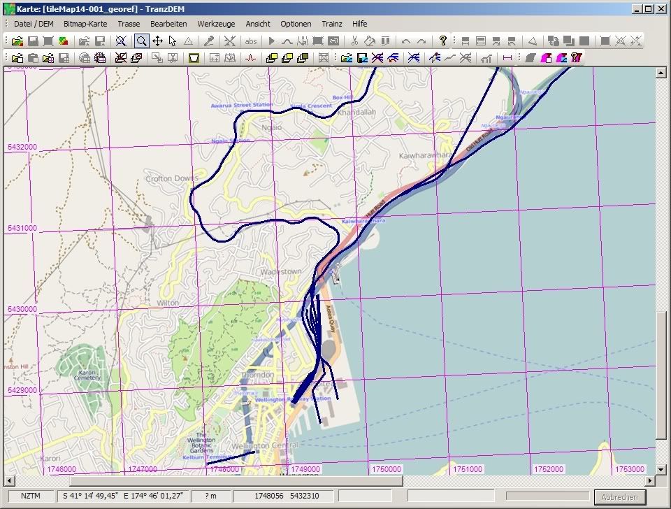
BQ31 railway_cl.shp loaded on top of Open Street Map (It seems, OSM is actually using LINZ data):