Error reading georeferenced raster map
Error reading georeferenced raster map
Well I am stuck again and this is where. I am at "Ready to create the route and export the UTM tiles" on the PDF "How to use Google Earth and TransDEM to create routes for Trainz". I can get the route's .dem file on the TD, but when I load the route's master .lgb I get an error. "error reading georeferenced raster map "\\Mac\Home\Desktop\Stevens Pass - 4/1_georef.trf". The file I am trying to load is "Stevens_Pass_Master.lgb. But the file name in the error is "georef.trf. I am not that good on computers but I can see that's not the same file I entered. What did I do wong? Thanks Br0563718
Re: Error reading georeferenced raster map
Inspect your .lgb file. It's plain text. Open it with a text editor. Notepad is fine.
It will have a list of files names without extension, each name usually ending on _georef.
An example for an .lgb file content:
TransDEM expects the actual raster maps in the same folder in which your .lgb files resides. And for each item in the .lgb file there are two files associated with it. They both have the same name, but different extensions, .trf and .png. The .png file is the raster image, the .trf file has the TransDEM-specific geo referencing information for it.
So, for my example, in the folder of your .lgb file you should find:
tileMap-001_georef.png
tileMap-001_georef.trf
tileMap-002_georef.png
tileMap-002_georef.trf
Is that the case?
It will have a list of files names without extension, each name usually ending on _georef.
An example for an .lgb file content:
Code: Select all
tileMap-001_georef
tileMap-002_georefSo, for my example, in the folder of your .lgb file you should find:
tileMap-001_georef.png
tileMap-001_georef.trf
tileMap-002_georef.png
tileMap-002_georef.trf
Is that the case?
Re: Error reading georeferenced raster map
I am doing my route in incumbents of 88 .jpg and .kmz at a time and then merge them together in trainz later. I figure it would not be so monotints. I inspected my .lgb file and they do have the 1_georf to 88_georef in them. The only way I can get the .png and .trf files are to get them from the original folder that I saved them all in. But how do I put them the .lgb file? Thanks Br0563718
Re: Error reading georeferenced raster map
Your .lgb file will have 88 entries for 88 georeferenced map or ortho-image clippings. Each clipping consists of two files, e.g. 1_georef.png and 1_georef.trf. Put (copy/move) the 88 .png files and the 88 .trf files in the same folder together with your .lgb file:
1-88_georef.lgb
1_georef.png
1_georef.trf
2_georef.png
2_georef.trf
3_georef.png
3_georef.trf
...
87_georef.png
87_georef.trf
88_georef.png
88_georef.trf
1-88_georef.lgb
1_georef.png
1_georef.trf
2_georef.png
2_georef.trf
3_georef.png
3_georef.trf
...
87_georef.png
87_georef.trf
88_georef.png
88_georef.trf
Re: Error reading georeferenced raster map
I thought I would check if I did something wrong when I processed the files the first time around, so I did 70 more in google and started all over. I watched and doubled checked everything. The only step I didn't do was make a temporary folder (because the file is small) when loading the .trf to create a .lgb master file. Everything went great but the .png and .trf files are still not in the master.lgb file. I opened the stevens_pass.lgb file with notepad and copy and paste the .png and the .trf files into notepad and closed it. So now I have the 1_georef, 1_georef.trf, 1_georef.png files, all 70 each file types are in the stevens_pass.lgb. but I still get the same error, 70 of them. I am sorry I don't mean to be a pain. the last time 5 year ago and a windows based computer I didn't have this much trouble. Any ideas? thanks Br0563718
Re: Error reading georeferenced raster map
First of all, I would recommend to use Map Tile Servers. It's a one time setup, but after that so much more efficient than the semi-manual Google Earth method with placemarks.
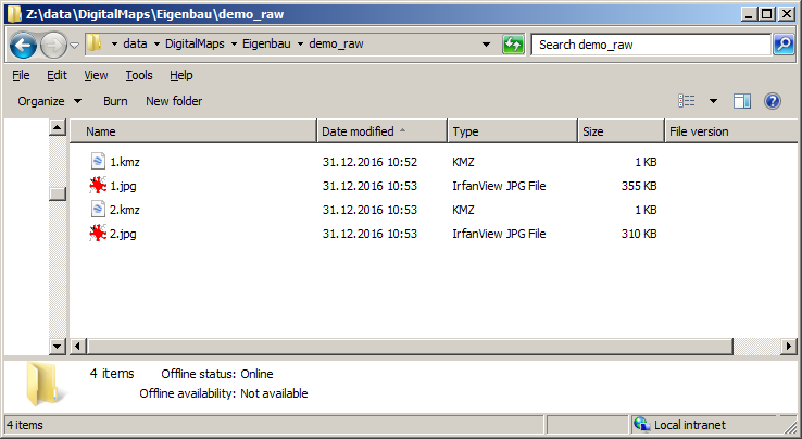
Anyway, if you do it with placemarks you will get two files per clipping, .kmz and .jpg. I put them the folder demo_raw, clippings 1 and 2.

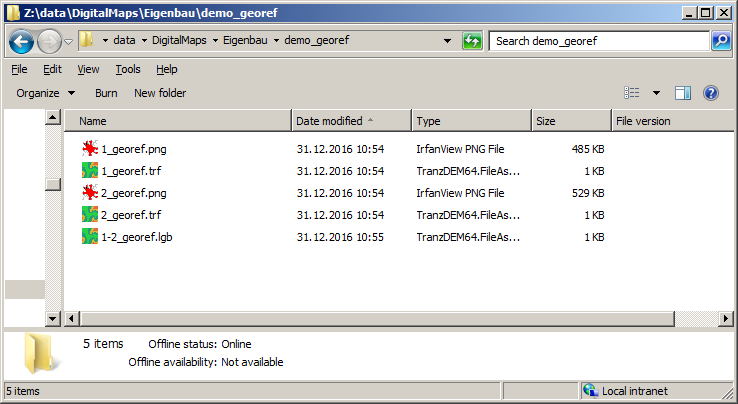
Then I georeference them and save the result in folder demo_georef. Again, I get two files per clipping, .trf and .png. Finally I open each georeferenced clipping individually, one after the other, and save the result as a group .lgb file. The lgb file is - and must be - in the same folder as the .trf and .png files.

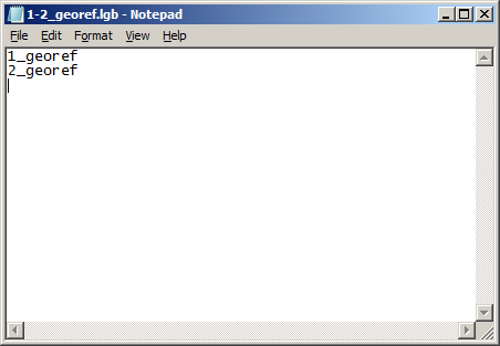
Inspecting the .lgb file in a text editor I see two entries, one for each clipping, without any file types.

That's the way it should look. What's different in your case?
With Map Tile Servers you would not not have to deal with the first bunch of files, .kmz and .jpg, because TransDEM would do that internally and produce georeferenced clippings right away. And, when acquiring map tiles along a path, even create the .lgb file for you.
Anyway, if you do it with placemarks you will get two files per clipping, .kmz and .jpg. I put them the folder demo_raw, clippings 1 and 2.

Then I georeference them and save the result in folder demo_georef. Again, I get two files per clipping, .trf and .png. Finally I open each georeferenced clipping individually, one after the other, and save the result as a group .lgb file. The lgb file is - and must be - in the same folder as the .trf and .png files.

Inspecting the .lgb file in a text editor I see two entries, one for each clipping, without any file types.

That's the way it should look. What's different in your case?
With Map Tile Servers you would not not have to deal with the first bunch of files, .kmz and .jpg, because TransDEM would do that internally and produce georeferenced clippings right away. And, when acquiring map tiles along a path, even create the .lgb file for you.
Re: Error reading georeferenced raster map
OK I did as you said. I ended up with the .lgb, .png and .trf all in one folder. Still get the same error. I think I'll see if I can find a tutorial on Map Tile Servers. I hate to give up but not working. I will let you know. Thanks again for all you time and efforts. Br0563718
Re: Error reading georeferenced raster map
You are right, using the Map Tile Servers is easy. I followed tutorial #7 in the TransDEM pdf. Thanks. For the past 3 hours Iv'e been looking on the web on How to enter all the files I created with Map Tile Servers into TransDEM. There is a lot out there, and maybe that's my problem-to much. but I can't find anything to show be the next steps. Can you point me in the right direction? thanks Br0563718
Re: Error reading georeferenced raster map
With Map Tile Servers you have two acquisition modes. The first is the default "one-by-one" clipping mode, the second the fully automatic "along a path" mode. The first creates a .trf and a .png file for each clipping, the second does the same but also automatically creates the .lgb file. To reload in TransDEM you simply open one or many of the .trf or .lgb files with the "open georeferenced raster map" function.
Re: Error reading georeferenced raster map
Ok Assuming I am to continue with the “TransDEM and Google Earth “ pdf at “Ready to create the route and export the UTM tiles” paragraph . I opened TD and everything went ok according to “TransDEM and Google Earth “ pdf. Until I got to Trainz/Export & Create:UTMTiles. A “ Export to Trainz: UTM Tiles as Overlay Objects (Automatic Placement” . dialog box comes up. It says: In the dialog box that appears, ensure that the radio button for "complete 'UTM' objects"
is enabled. That radio button is not on the box I see. And the “Export Destination” is parcelly grayed out. I added through the folder bottom I changed the source of the UTM03 to: C:\Program Files\Ziegler-Tools\UTM03 where it’s on my computer. I click OK. An error comes up “Errors writing file “(UTM Overlay Objects)” No UTM tiles in mask or filter range. I went back to the “ Export to Trainz: UTM Tiles as Overlay Objects (Automatic Placement “ dialog box and under Route Filter the Apply box was checked, but no numbers in Radius. I am assuming this is about the number of route boards from the track, so I put 2 in. And I still get the error “Errors writing file “(UTM Overlay Objects)” No UTM tiles in mask or filter”. I tried to put a photo in. thanks Br0563718 [img]Export to Trainz- UTM Tiles a Overlay Objects .jpeg/img]
is enabled. That radio button is not on the box I see. And the “Export Destination” is parcelly grayed out. I added through the folder bottom I changed the source of the UTM03 to: C:\Program Files\Ziegler-Tools\UTM03 where it’s on my computer. I click OK. An error comes up “Errors writing file “(UTM Overlay Objects)” No UTM tiles in mask or filter range. I went back to the “ Export to Trainz: UTM Tiles as Overlay Objects (Automatic Placement “ dialog box and under Route Filter the Apply box was checked, but no numbers in Radius. I am assuming this is about the number of route boards from the track, so I put 2 in. And I still get the error “Errors writing file “(UTM Overlay Objects)” No UTM tiles in mask or filter”. I tried to put a photo in. thanks Br0563718 [img]Export to Trainz- UTM Tiles a Overlay Objects .jpeg/img]