TransDEM Forum

TransDEM News, Support, Hints and Resources
It is currently 27 Apr 2024 15:07

All times are UTC + 1 hour


Post new topic Reply to topic  [ 8 posts ] 
Author Message
PostPosted: 14 Aug 2011 10:11 
Offline

Joined: 05 Jan 2011 16:45
Posts: 1465
Configuration data has been updated today: TransDEM Sample Settings

For WMS, a couple of entries have been removed. Those servers are no longer active. A few others have changed their address. The new and still incomplete USGS "National Map" service has been added.

For Map Tiles, I have added Australian "Near Map" and "Historic UK". Some others have been modified to reflect newer version numbers in their URL.


Top
 Profile  
 
PostPosted: 15 Aug 2011 02:03 
Offline

Joined: 30 Jan 2011 13:03
Posts: 170
G'day geophil,

Thank you for doing that, Roland...

...there seems to be one problem, though...

...although I haven't actually tested out the WMS settings yet, I did check the Tile Map Server settings and it seems that all is well, except that the Historic UK Server doesn't want to play ball. I can get map displays from all of the other optiions but if I select Historic UK from the list, nothing appears happen...

...speaking of "others", I notice a few of the servers have "Other" and/or "Other1, 2 or sometimes 3" as options for their displays. Are these options explaned in any of the manuals? If they aren't, to what do they refer or more specifically, what 'options' can we obtain by selecting them?

Jerker {:)}


Top
 Profile  
 
PostPosted: 15 Aug 2011 09:06 
Offline

Joined: 05 Jan 2011 16:45
Posts: 1465
Garry,

that online collection of historic UK topo maps was discovered by Vern. They offer several layers there, not all adhering to the Map Tile de-facto standard. I picked those which fit. Here is more: http://forum.transdem.de/viewtopic.php?p=493#p493.

The tile type "Other n" is just a place holder for a different layer, assigned arbitrarily. In the case of "Historic UK", "Other n" refers to a different map source.

Of the four sources in "Historic UK", only "Other 2" covers the entire planet, or, more precisely, offers tiles for all zoom levels. The others start at zoom level 6.


Top
 Profile  
 
PostPosted: 22 Nov 2011 13:37 
Offline

Joined: 05 Jan 2011 16:45
Posts: 1465
A new release of the configuration data (Nov 2011) is available at the usual place: TransDEM Sample Settings.

There are three new or modified WMS entries:
  • Alaska (alaskamapped.org), new
  • USGS National Map, modified
  • Mexico INEGI, new


Top
 Profile  
 
PostPosted: 24 Jan 2012 19:04 
Offline

Joined: 28 Mar 2011 03:35
Posts: 83
May be worth checking out the Polish links Roland. Playing around this afternoon, although the connection to server is established, all the categories of 10k, 25k, 50k and 100k were simply downloading as blanks, no topographic data. Unfortunately Google Earth and OSM don't really give very good coverage in the area I was interested (South East/Carpathian Mountains).


Top
 Profile  
 
PostPosted: 10 Mar 2012 16:27 
Offline

Joined: 30 Jan 2011 13:03
Posts: 170
G'day geophil,

Roland, I'm currently doing some work on routes in Tasmania. I'm being 'disappointed' by the results I am getting using OSM as my (only available) option for the topographic maps (even the 'new' transport 'variation'). I was wondering if it might be possible to 'find' a "Tile Map" URL and appropriate 'settings' that would allow me to source the official L. I. S. T. Topographic maps (whose 'display' is of a more 'traditional style') by means of the "Tile Map Server" function in TransDEM?

Jerker {:)}


Top
 Profile  
 
PostPosted: 12 Mar 2012 10:56 
Offline

Joined: 05 Jan 2011 16:45
Posts: 1465
Garry,

LISTmap isn't a map tile system. There could be a WMS behind it, but that's hidden from us.

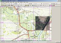
However, the map viewer is fairly easy to use with 3+1 point georeferencing. Coordinates are MGA/GDA94, zone 55, by default. For our purposes, MGA/GDA94 is the same as UTM/WGS84. The maps in the viewer bear a 1000m grid (unless you switch it off). With the coordinate display in the map viewer status bar you should have all the information required. Don't forget to click "Southern Hemisphere" for the fist map clipping. From the second clipping onward and as long as you do not change map viewer scale, you will only need the first point for each clipping, usually a grid line intersection near the SW corner, because TransDEM remembers the other transformation parameters.

Georeferenced LISTmap clipping with orthophoto overlay from Virtual Earth /Bing Maps:
Image

Regarding OSM, that's mostly up to us as users and contributors. For Madagascar, a fellow traveller and I have completed the railway network in the last few weeks, based on our GPS track logs and observations. I'm now diving into my archives of two other trips a few years ago, to Eritrea and Burma, also with useful and usable GPS data.


Top
 Profile  
 
PostPosted: 12 Mar 2012 16:41 
Offline

Joined: 30 Jan 2011 13:03
Posts: 170
G'day geophil,

Bugger!! Indeed, Roland, I was aware of everything you've mentioned (and have already 'downloaded' several map clippings as part of the project, in the manner you suggest). Its just that (as you will be aware) the area of the displayed map is in such a proportion that needs requires at least two clips from the viewer to cover an area equal to one clip obtained from the Map Tile Server. I was really just trying to save myself a whole lot of work. Never mind, I shall carry on regardless. Thanks for looking into it for me, anyway...

Jerker {:)}


Top
 Profile  
 
Display posts from previous:  Sort by  
Post new topic Reply to topic  [ 8 posts ] 

All times are UTC + 1 hour


Who is online

Users browsing this forum: No registered users and 26 guests


You cannot post new topics in this forum
You cannot reply to topics in this forum
You cannot edit your posts in this forum
You cannot delete your posts in this forum

Search for:
Jump to:  

Imprint & Privacy

Powered by phpBB® Forum Software © phpBB Group