TransDEM Forum
https://forum.transdem.de/

Geo Data - Great Britain
https://forum.transdem.de/viewtopic.php?f=8&t=5
Page 2 of 3

Author:  BigVern [ 04 Jul 2011 18:16 ]
Post subject:  Re: Geo Data - Great Britain

Thanks for that Roland, I've imported the data into Transdem and it is recognised, just need to apply it to overlaying a route - which will probably be in a couple of weeks when I finish my current RW project.

Author:  geophil [ 03 Jul 2013 13:02 ]
Post subject:  UK Ordnance Survey OS Terrain 50

UK Ordnance Survey OS Terrain 50®

This is a new DEM product in the O/S Open Data portfolio.

It should be at least as good as Land-form Panorama which is no longer updated. Like its predecessor, the grid width is 50 m, hence the name.

See here for technical details: http://www.ordnancesurvey.co.uk/oswebsi ... index.html

The package can be downloaded from the Open Data product page. The data is available in different formats. TransDEM supports the raster variant (DTM) in ASCII grid format (aka ESRI grid). File type is .asc. Download size is approximately 162MB.

All other info is the same as for Land-form Panorama:

Data is packed into tiles of 20 x 20 km and structured by O/S grid squares. To find the grid square, an overview map should be loaded in TransDEM and the coordinate system switched to OSGB36. Grid square codes are shown in the TransDEM status bar, if the View | Show grid square option is activated. The numerical digits in the file name indicate the 20 km tile in square coordinates, the first digit for the easting, the second digit for the northing.

The tile files can be opened in TransDEM as ordinary DEMs. TransDEM will detect that the coordinates are not geographic and ask for the coordinate system. If the coordinate system has not already been switched to OSGB36 in the main menu it must be set so for each tile file individually.

Author:  BigVern [ 03 Jul 2013 14:48 ]
Post subject:  Re: Geo Data - Great Britain

Is this the same data which is available on UKTS in pre-packaged chunks?

Author:  geophil [ 03 Jul 2013 16:00 ]
Post subject:  Re: Geo Data - Great Britain

IIRC the source for them was Land-form Panorama. OS Terrain 50 is a very recent addition.

Author:  wheelsonfire [ 13 Jul 2013 08:31 ]
Post subject:  Re: Geo Data - Great Britain

Thanks for the Historic UK settings for the Map Tile Servers, but I don't get anything from the 1:25,000 link (Other 1). A word of advice to new users as well - zoom into the UK using one of the other maps before clicking on the Historic UK options or you'll just get a black screen.

Author:  geophil [ 13 Jul 2013 22:41 ]
Post subject:  Re: Geo Data - Great Britain

wheelsonfire wrote:
but I don't get anything from the 1:25,000 link (Other 1)
Yes. This has changed apparently and access seems to be more indirect now. Try the following:

Copy the code section into a text editor, save as an xml file and import into TransDEM with the Map Tile Client / Settings.

Code:
<?xml version="1.0" encoding="iso-8859-1" ?>

<TileServer version="1.0" >
  <Provider name="8 Historic UK" >
    <URL addr="http://www.sabre-roads.org.uk" prefix="maps/tile.php?l=os1" standalone="1" type="4" >
      <Matrix prefixClm="&amp;x=" prefixRow="&amp;y=" prefixZoom="&amp;z=" minZoom="6" maxZoom="16" order="2" />
      <Mercator origLat="90" origLon="-180" signLat="-1" signLon="1" projection="4" />
    </URL>
  </Provider>
</TileServer>

Author:  wheelsonfire [ 14 Jul 2013 06:58 ]
Post subject:  Re: Geo Data - Great Britain

That fixed it. Thanks Roland.

Author:  Jerker [ 16 Jul 2013 03:39 ]
Post subject:  Re: Geo Data - Great Britain

G'day geophil,

Roland, I was wondering if that code you have just 'published', above, is different to the code for the Historic UK Tile Map Server, that was provided with the most recent update or if, on the other hand, that recent update includes that code for the Historic UK server? If the former, then I would venture that it would be 'wise' if I (and all other transDEM users, for that matter) also follow your instructions, so as to have all our Map Tile Servers up-to-date...

Jerker {:)}

Author:  geophil [ 16 Jul 2013 08:41 ]
Post subject:  Re: Geo Data - Great Britain

When I checked the settings in the collection for the latest update, this particular source already failed, but I did not investigate. It was the question by wheelsonfire that made me take a closer look.

When you follow the instructions with the do-it-yourself xml file, it will update that particular "Other 1" type in the "Historic UK" group.

There is also a version change in the Yandex settings, discovered yesterday.

Author:  geophil [ 19 Jun 2015 10:03 ]
Post subject:  Re: Geo Data - Great Britain

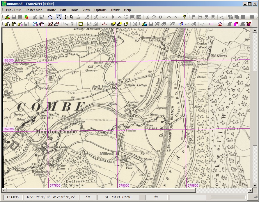
A new map tile addition from the National Library of Scotland, six inch to the mile - that's an amazing 1:10560 :o - for England and Wales.

Copy the code section into a text editor, save as an xml file and import into TransDEM with the Map Tile Client / Settings.

It will override the previous definition of "Other 3" which has been defunct for a while.

Code:
<?xml version="1.0" encoding="iso-8859-1" ?>

<TileServer version="1.0" >
  <Provider name="8 Historic UK" >
    <!-- Six-inch England and Wales 1888-1913 -->
    <URL addr="http://nlsapi.tileserver.com" prefix="os_6_inch_gb/" postfix=".jpg" standalone="1" type="6" >
      <Matrix prefixClm="/" prefixRow="/" minZoom="1" maxZoom="17" order="2" />
      <Mercator origLat="90" origLon="-180" signLat="-1" signLon="1" projection="4" />
    </URL>
  </Provider>
</TileServer>


Example: Somerset Coal Canal, near Bath, fell into disuse before WW I.

Image

Page 2 of 3 All times are UTC + 1 hour
Powered by phpBB® Forum Software © phpBB Group
http://www.phpbb.com/