A few days ago version 2 of ASTER GDEM has been released.
The ASTER satellite mission is a joint research project by NASA and Japanese institutions. One of the results is the ASTER GDEM digital elevation data product, data acquired by an infra-red sensor aboard the satellite.
About 8 years ago, in the early days of ASTER DEMs, the first data files were made available. Coverage was sparse, and DEMs were error prone, systematic vertical and even horizontal deviation, artefacts (dells and peaks), large holes. Occasionally however, the DEMs weren't bad at all. Getting access to the data took some effort, though. Later on, a fee was levied for this service and ASTER DEMs went out of focus.
Then, in spring 2009, a new generation of ASTER DEM was published, the result of a lot of systematic and sophisticated post-processing, and now covering almost the entire globe. It was called ASTER GDEM, became free of charge again, but limited to scientific purposes officially. Quality had improved significantly, but artefacts were still there. And, obtaining the ASTER data was still much more complicated than obtaining SRTM data.
Nevertheless, with GDEM, ASTER DEMs became interesting again. With the right tool, the user can fix certain DEM faults himself. Some of the TransDEM features for DEM editing were explicitly designed to tackle typical ASTER challenges, and were implemented during the first phase of publicly available ASTER DEMs with all their issues.
ASTER is an ongoing mission. For version 2 of the GDEM project more sensor samples were processed in a superimpose/merge algorithm which eliminates several artefacts and allows for less smoothing (low pass filtering), providing higher DEM definition. Nominal resolution of the sensor is 30 m and GDEM version 2 is getting closer to this nominal value.
GDEMs are delivered as GeoTIFF files. They are in Plate-Carrée pseudo projection, like many other DEM resources, including SRTM. Nominal resolution is 1 arc sec, approx. 20 x 30m in the temperate zones.
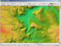
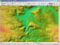
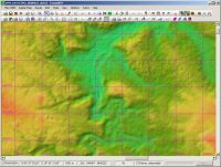
Here is a comparison between SRTM, ASTER GDEM 1 and 2, for a region in Poland, Lower Silesia, near Jelenia Góra, with 1000 m UTM grid lines:
Firstly SRTM 3 arc sec:
ASTER GDEM in version 1 (1 arc sec nominally):
ASTER GDEM in the new version 2 (1 arc sec):
ASTER GDEM is available from the NASA ECHO database. Until now access was via the WIST portal which will be replaced the more user-friendly
ECHO-Reverb. Registration is required. Existing accounts (created with WIST and before) remain valid.


