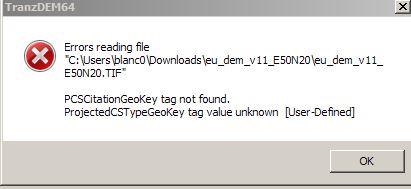
GeoTIFF is a difficult beast. While theoretically standardized there are so many options a supplier can choose from. And if that is not enough, he can define custom ones. I recently discovered that certain data sources that cover EU-wide territory use a very unusual projection:
Lambert azimuthal equal-area. It could be the same case here. This projection has the theoretical advantage of a single zone for all of Western and Central Europe, but it is so uncommon that some suppliers don't even know it has an EPSG code. That wouldn't have helped here, though, as TransDEM has not implemented this projection. I may add it in the end, but as long as there are other sources with the same quality but a more common projection, I don't see the necessity.
Checking the
Copernicus website, it says, their "EU-DEM v1.1" is a combination of SRTM and ASTER. In that case you can also try the NASA-DEM product which is very similar but comes in hgt format and the well-known Plate Carrée pseudo projection:
viewtopic.php?p=3123#p3123