TransDEM Forum

TransDEM News, Support, Hints and Resources
It is currently 27 Apr 2024 18:14

All times are UTC + 1 hour


Post new topic Reply to topic  [ 6 posts ] 
Author Message
PostPosted: 17 Mar 2012 18:36 
Offline

Joined: 05 Feb 2011 13:18
Posts: 104
Hello everybody,

As trainz doesn't allow the user to make a large route in one step, I have to create several routes in order to reach my goal.

This goal is the complete Belgian railwaynet in the most realistic way.

After some calculations the routes can have approx 50 maps NS and 50 maps EW. This amount of maps lead to a filesize of approx 500Mb which seems to be no problem for Trainz.

The problem is the following: Is there a method that I can use in Transdem to create my routes, in order to allow me to do a perfect merge in Trainz.

Overlapping is not possible to connect one route to another.

Does anyone have some ideas?

Thank you

Best regards

Kurt


Top
 Profile  
 
PostPosted: 17 Mar 2012 22:26 
Offline

Joined: 05 Jan 2011 16:45
Posts: 1465
Kurt,

TransDEM maintains a static mapping between baseboard edges and UTM coordinates. As long as you stay in the same UTM zone, 31 in your case, seamless merging should always be possible, provided you create the right baseboards, without any gaps and ideally without overlapping. TransDEM will assist you here.

(Note: Don't fiddle with "UTM grid offsets" when seamlessly merging TransDEM-only modules.)

Assume you export a first module. Let us further assume that this is the module at the western end of your route. A next module would join in the east.

Switch on the Trainz baseboard grid in TransDEM and take a mental note of the eastern border of your first module. You don't have to take a screenshot or write down the coordinates, TransDEM will do that for you. Any route module created with TransDEM will get one additional text file "<name_of_module>_TransDEM_info.txt".

The text file will show the bounding box of the module as UTM coordinates of the corners.

What you will be interested in is the eastern edge since the first module was defined as the westernmost in this example. You will continue eastward and need to know the coordinates of the eastern edge, which is labeled as "UTM Northeast Corner Easting" in the file and has a value of "370400" here.

Code:
TransDEM Trainz Export ---  © 2006-2011 Roland Ziegler

Geodetic Datum = WGS84
UTMZone = 32U

UTM Southwest Corner Easting  =  368240
UTM Southwest Corner Northing = 5668560

UTM Northeast Corner Easting  =  370400
UTM Northeast Corner Northing = 5670720

Extension East-West   =   2.160 km
Extension North-South =   2.160 km

Trainz World Origin = N 51° 09,795'   E 7° 07,861'

Baseboard UTM Grid Offset: x = 0 m,  y = 0 m

# Trainz Baseboards East-West                        = 3
# Trainz Baseboards North-South                      = 3
# Trainz Baseboards total                            = 9
# actually created Trainz Baseboards after filtering = 9
# hereof in 5 m grid                                 = 9

Actual Elevation Range Minimum =    96 m
Actual Elevation Range Maximum =   256 m


For your next module you will have to set the export mask slightly left to the eastern border of the previous module. Check the UTM coordinates in the status bar or with the help of the UTM grid labels.

Once you have opened the export dialogue you have an option for final adjustment:

Image

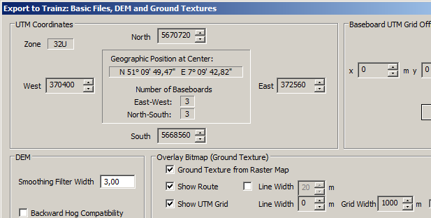
The "West" field must show "370400" again. If it doesn't change the value with the up/down control ("Spin button" in MS lingo). You may notice that each click adds or subtracts 720. As I said in the beginning, there is a static mapping between baseboard edges and UTM coordinates. Each baseboard is 720 m wide, and it will always be a multiple of 720m away from the UTM zone origin. Therefore, if you select the right baseboard edge in the new module, it will always fit to the previous module.


Top
 Profile  
 
PostPosted: 18 Mar 2012 10:30 
Offline

Joined: 05 Feb 2011 13:18
Posts: 104
Hello Roland,

Thank you for your detailed information. :D

The UTM zone remains 31.


The route starts with a Tramroute which follows a major part of the Belgian coast. Along the tramroute there are 7 railwaystations.
Therefore, presently, I'm drawing the tracks of the railwaynet with Transdem just like in the real world. I probably will have to make a Westcoast and a Eastcoast section due to the limitations of Trainz ( max 500Mb)

When I created the tramroute with transdem, I didn't use the option Export & create UTM tiles. I already made some changes to the route ( that is, the tracks, stopplaces tram and the road are present ).

Is this a problem for the future connection with the method you have given me?

If it is, can I implement the export & create utm tiles without any major changements to my tramroute ( as it is at this moment ).


Best regards

Kurt


Top
 Profile  
 
PostPosted: 18 Mar 2012 18:21 
Offline

Joined: 05 Jan 2011 16:45
Posts: 1465
Belgian46 wrote:
When I created the tramroute with transdem, I didn't use the option Export & create UTM tiles. I already made some changes to the route ( that is, the tracks, stopplaces tram and the road are present ).

Is this a problem for the future connection with the method you have given me?

No, it's not a problem. The only thing you have to do after merging is to fix the Trainz World Origin (WO) object. TransDEM has a function to do that.

The WO in a TransDEM-created Trainz route holds the UTM coordinate reference for TransDEM. It not only points to the geographic coordinates (lat/long) of its location but also enables TransDEM do deduce the UTM coordinates from this. Knowing the UTM coordinates is essential to add UTM tiles or spline objects at a later stage. Unfortunately, when merging two modules in Surveyor the WO goes astray (in most cases). In Trainz Content Manager, open the merged route for editing and call the "Repair World Origin" in TransDEM to fix this. After that you can add UTM tiles or spline objects to any place of the merged route.


Top
 Profile  
 
PostPosted: 18 Mar 2012 21:43 
Offline

Joined: 05 Feb 2011 13:18
Posts: 104
geophil wrote:
Belgian46 wrote:
When I created the tramroute with transdem, I didn't use the option Export & create UTM tiles. I already made some changes to the route ( that is, the tracks, stopplaces tram and the road are present ).

Is this a problem for the future connection with the method you have given me?

No, it's not a problem. The only thing you have to do after merging is to fix the Trainz World Origin (WO) object. TransDEM has a function to do that.

The WO in a TransDEM-created Trainz route holds the UTM coordinate reference for TransDEM. It not only points to the geographic coordinates (lat/long) of its location but also enables TransDEM do deduce the UTM coordinates from this. Knowing the UTM coordinates is essential to add UTM tiles or spline objects at a later stage. Unfortunately, when merging two modules in Surveyor the WO goes astray (in most cases). In Trainz Content Manager, open the merged route for editing and call the "Repair World Origin" in TransDEM to fix this. After that you can add UTM tiles or spline objects to any place of the merged route.


Hello Roland,


Well, thank you for the positive news.
I'm really happy that I can continue with the tramroute as it is right now :D

Until the next

Best regards

Kurt


Top
 Profile  
 
PostPosted: 22 Mar 2012 15:52 
Offline

Joined: 12 Apr 2011 03:30
Posts: 21
The information in the "<filename>_TransDEM_info.txt" file found in the export folder is so important for future merging that I keep scraps of paper by the computer to write down module boundaries it contains. This is important for setting up the next export. My method may be helpful, though it is hardly high-tech. I write the information in a three-row grid like the one below.

<UTM Northeast Corner Northing>

<UTM Southwest Corner Easting> <Module Name> <UTM Northeast Corner Easting>

<UTM Southwest Corner Easting>

Names in brackets are the actual values for those items. For instance, <UTM Northeast Corner Easting> shows where I put that value in the grid; it is on the east side of the diagram!

This puts the module boundary locations at a glance making it easier to set the borders of the adjacent module during export.

I am sure there is a more elegant way to remember these things.

George


Top
 Profile  
 
Display posts from previous:  Sort by  
Post new topic Reply to topic  [ 6 posts ] 

All times are UTC + 1 hour


Who is online

Users browsing this forum: No registered users and 24 guests


You cannot post new topics in this forum
You cannot reply to topics in this forum
You cannot edit your posts in this forum
You cannot delete your posts in this forum

Search for:
Jump to:  

Imprint & Privacy

Powered by phpBB® Forum Software © phpBB Group