TransDEM Forum

TransDEM News, Support, Hints and Resources
It is currently 27 Apr 2024 19:34

All times are UTC + 1 hour


Post new topic Reply to topic  [ 11 posts ]  Go to page 1, 2  Next
Author Message
PostPosted: 25 Feb 2012 21:21 
Offline

Joined: 21 Feb 2012 16:57
Posts: 9
OK The map "Other 1" for "British War Office - Ireland" displays in tile services but how do I get this map into Transdem. (not as the tiles ) The tutorial says that to generate multiple tiles I need to draw a path on the map in transdem. Currently I have no map. How do I get the Irish maps into it? Do I use web mapping services? Is there an xml code for that? Feeling overwhelmed at the moment.


Top
 Profile  
 
 Post subject: Re: Geo Data - Ireland
PostPosted: 26 Feb 2012 07:39 
Offline

Joined: 30 Jan 2011 13:03
Posts: 170
G'day spruce,

...did you not read the remainder of the tutorial to ascertain that which should be done next?...

...make sure that you have the view at the point where you wish to start, visible in the Tile Server Window. You can ensure that this point is returned to later, if the need arises, by pressing the button with the right pointing arrow on it (which will place the coordinates of the centre of the current window image into the Latitude and Longitude text boxes and if you then press the little button labelled 'fix', this will lock these co-ordinates, so that this point is fixed (if you do need to return to this point, clicking the button with the left facing arrow will do this). Next, you click on the [Get Map] button. Some time will pass, after which, you will be requested to provide a location and name to store the file being downloaded. Once you have decided on both a name and location, the file will be saved and after a short time (depending on the size of the file and the speed of your internet connection), the file will be saved and will appear in the main TransDEM window. Move the view in Tile Server Window to the next tile you wish to import (read "tot the next point along your railway line near the edge of the current view) and repeat the process...


...I'm sure that's what is written in the tutorial (give or take a few words)...

Jerker {:)}


Top
 Profile  
 
 Post subject: Re: Geo Data - Ireland
PostPosted: 26 Feb 2012 12:06 
Offline

Joined: 21 Feb 2012 16:57
Posts: 9
Hi Jerker
Thanks for the reply. I think I understood how to manually generate tiles one by one though I have not done it yet. What has confused me is the automatic generation of tiles. For that I need a map in Transdem on which I can draw a path. Then get the tile server to make tiles along that path. How do I get the original Irish map into Transdem upon which I draw a path?


Top
 Profile  
 
 Post subject: Re: Geo Data - Ireland
PostPosted: 26 Feb 2012 14:28 
Offline

Joined: 30 Jan 2011 13:03
Posts: 170
G'day spruce,

...dare I say it, that isn't the way your question reads but that may not necessarily be your fault...

...the easiest way I know of to achieve the result you want, is, in fact, not to use any maps in TransDEM at all but to create the polyline outside of the program, using Google Earth and it's *.kzm file utility. Use GE to 'trace' the route you wish to cover by means of a *.kzm path, import this file into TransDEM via the "route" import function (note, you must have at least one correctly georeferenced Tile Map or some DEM covering a portion of the area needed for this to 'work') and you can then use this imported polyline to provide the basis for the [Get Map Along Path] option...

...in this way, you can get the whole route in one fell swoop and you don't need to be too fussy with the corners/bends, as you can modify the polyline once it is in TransDEM to more accurately follow the railway line you are following...


Jerker {:)}


Top
 Profile  
 
 Post subject: Re: Geo Data - Ireland
PostPosted: 26 Feb 2012 16:37 
Offline

Joined: 21 Feb 2012 16:57
Posts: 9
Hi Thank you for taking the trouble to assist me.

My problem is that I am trying to model a disused railway. Beeching got at it in 1952. The maps I have, that show the railway, are the ones that existed in the 1930s. Google Map is too modern. I have dozens of photographs of the railway track taken from a 1930's 6inch OS map but I wanted to try the automatic tile method. The full track path is displayed on the Irish maps discussed above which I have managed to get into the tile server. I have the DEM loaded for the area. I thought it would be possible to load the Irish map in as a raster map. Then I could generate a path of the railway track from which I could generate the tiles.

Alan


Top
 Profile  
 
 Post subject: Re: Geo Data - Ireland
PostPosted: 26 Feb 2012 19:52 
Offline

Joined: 05 Jan 2011 16:45
Posts: 1465
Alan,

one of the key features of TransDEM is its ability you combine all sorts of maps or images, be it manually georeferenced, from a Map Tile service, via WMS (not in your case), or aerial images from Google Earth. TransDEM will take care of position, scale and extent of each individual map clipping.

An easy approach would be to download a modern map at medium scale via a Map Tile service, e.g. Open Street Map. On this map you roughly sketch the former course of your disused railway with the built-in polyline editor, then use this a path to automatically download the larger scale historic maps which you finally export to Trainz as ground textures, in combination with the DEM to shape the terrain.

I recommend to have a look at the Map Tile tutorial again (TransDEM main manual). Remember that you don't have to stick to a single map source. You can switch the source any time you like. And also look at the "Muengsten" tutorial once more, illustrating the process of exporting to Trainz, with different map sources for ground textures and UTM tiles.


Top
 Profile  
 
PostPosted: 27 Feb 2012 13:58 
Offline

Joined: 30 Jan 2011 13:03
Posts: 170
G'day spruce,

Roland's suggestion to consider 'the greater picture', Alan, may well solve your problem but I must ask; Which line is it you are 'chasing'? You see, it is my general experience that both of the current, official Irish OS map providers 'supply' maps that would easily date back to 1952 and would thus, provide you with the location of your chosen railway line within a topographic map of 'modern' style, that would be ideal for your purposes. As Roland has noted, these maps may need to be manually georeferenced and that's something that we just have to 'wear', as we can't always have it the easy way. However, given that I have created routes for nearly all of the dismantled, former railway lines in Northern Ireland (including all of the narrow gauge lines) for another Trainzer, I know the job can be done...

Jerker {:)}


Top
 Profile  
 
PostPosted: 27 Feb 2012 23:05 
Offline

Joined: 21 Feb 2012 16:57
Posts: 9
Hi Jerker

"it is my general experience that both of the current, official Irish OS map providers 'supply' maps that would easily date back to 1952 "

When you say official Irish OS map providers do you mean that these are freely available and can be included in Transdem?

I have created raster maps from my photographs for the line from Downpatrick to Saintfield as a first step. That is the BCDR. I drew a poly line on them and used the tile server to produce tiles from the Irish maps given by Saber. I got a nice set of tiles. :) Need to import them into Trainz to see what it looks like. As you can see I am slowly progressing.

What official map could I use to draw a poly line on? Is there one that gives the whole of Co Down?

Perhaps it will just end up with me using all my photographs.


Top
 Profile  
 
PostPosted: 28 Feb 2012 02:38 
Offline

Joined: 30 Jan 2011 13:03
Posts: 170
G'day spruce,

Indeed, Alan, when I say 'official', I mean the 'official' sources "osi.ie" and "geohubni", both of which offer 'free' "viewers" which can be used with TransDEM (using the 'screen capture' process) to obtain perfectly workable routes. The former BCDR line from Belfast to Newcastle (including the branches to Donaghadee, Bangor, Ardglass and Ballynahiinch) is amongst those I mentioned above, for which I used the 'maps' provided by GeohubNI. This is not an automated process, every map must be laboriously georeferenced by hand and although it is time consuming, it can be done. Here's the TransDEM screen output of the area around Saintfield from the aforementioned 'route'...

Image


...the topographic maps you see in the image have all been sourced 'online' and here is a screenshot of the 'output' from GeohubNI showing the former station area at Saintfield (in the middle of the map view) in the 1:5000 scale maps available from them (and you can get closer still), all still showing the location of the former Right of Way, despite it not having been there since 1952...

Image

Jerker {:)}


Top
 Profile  
 
PostPosted: 28 Feb 2012 11:01 
Offline

Joined: 05 Jan 2011 16:45
Posts: 1465
Let me get back to the basics first as I have the impression it is there where the problem is.

Let's assume we want to recreate the Belfast & County Down Railway. Fortunately there is a website: http://www.downrail.co.uk/history/index.htm. We are even more lucky as they offer a contemporary map of the railway: http://www.downrail.co.uk/history/photos/BCDR/BCDRmaplarge.jpg
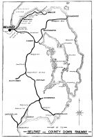
Image


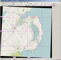
With the whereabouts now known we can start in TransDEM and an overview map. Easiest is a map tile service. I picked Open Street Map and went to zoom level 11, map size 1536 pixels. In TransDEM it will look like this:
Image


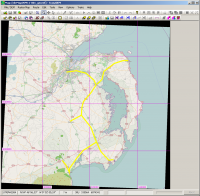
For the detailed maps, where we want the historical ones, we need a path. We have two options here. The quicker one is to roughly sketch the course of the former lines onto our Open Street Map clipping. It will be accurate enough. The slower one would be to georeference the old BCDR map and re-draw the line on top of that one. I'll show both.

This is my sketch on top of Open Street Map:
Image


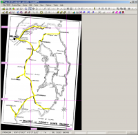
And this is my attempt to georeference the old map and draw upon that one. I used 3+1 corner georeferencing and entered the coordinates for Belfast, Donaghadee, and Newcastle which I obtained from my Open Street Map clipping I kept open in a separate TransDEM window.
Image


Now, either with the OSM overview map or with the original BCDR map and the path just drawn, I open the Map Tile client again and selected the historic 1:63,000 topographic map ("Historic Ireland"/"Other 1"). I left the map size at 1536 pixels, set the zoom level to 14 and started downloading along the path. The server is somewhat slow, so it will take a while.
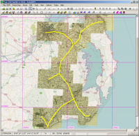
Image

I zoomed in and retraced the railway, now at the detail level of the topographic map.
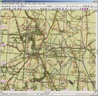
Image


Finally I combined with the DEM (and zoomed in again for some hills and dales):
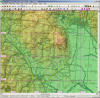
Image

At this point we are ready to export to Trainz. We have a DEM, a topographic map at a suitable scale for ground textures and basic vector data to guide the export process.


Top
 Profile  
 
Display posts from previous:  Sort by  
Post new topic Reply to topic  [ 11 posts ]  Go to page 1, 2  Next

All times are UTC + 1 hour


Who is online

Users browsing this forum: No registered users and 28 guests


You cannot post new topics in this forum
You cannot reply to topics in this forum
You cannot edit your posts in this forum
You cannot delete your posts in this forum

Search for:
Jump to:  

Imprint & Privacy

Powered by phpBB® Forum Software © phpBB Group