TransDEM Forum

TransDEM News, Support, Hints and Resources
It is currently 27 Apr 2024 15:42

All times are UTC + 1 hour


Post new topic Reply to topic  [ 20 posts ]  Go to page 1, 2  Next
Author Message
 Post subject: Google earth issues
PostPosted: 02 Sep 2011 20:54 
Offline

Joined: 02 Sep 2011 20:19
Posts: 11
I Am sure I am missing a step while using google earth and transdem. After I have gotten my images and everything. I then do the Shift O,Alt R, Shift U and the Alt S. then I am closing transdem and restarting it then Alt O. After that I am making my rectangular box. All goes bad on me then. First error I get is Inconsistent file names and or missing files for one or more map folders. And then I get "[UTM overlay objects]" no utm tiles in filter area. For the life of me I have looked 10 times on the tutorials and I dont know if I am just missing something or not. I just need a little shove in the right direction.


Top
 Profile  
 
 Post subject: Re: Google earth issues
PostPosted: 02 Sep 2011 21:46 
Offline

Joined: 05 Jan 2011 16:45
Posts: 1465
liebherr1280 wrote:
After I have gotten my images and everything. I then do the Shift O,Alt R, Shift U and the Alt S. then I am closing transdem and restarting it then Alt O. After that I am making my rectangular box.
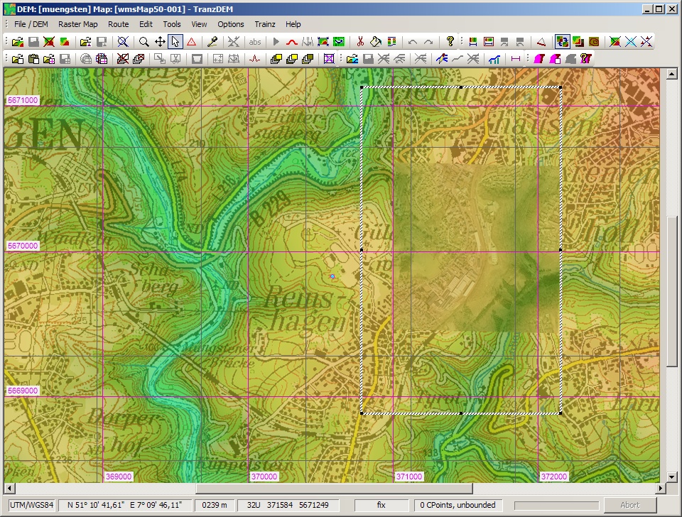
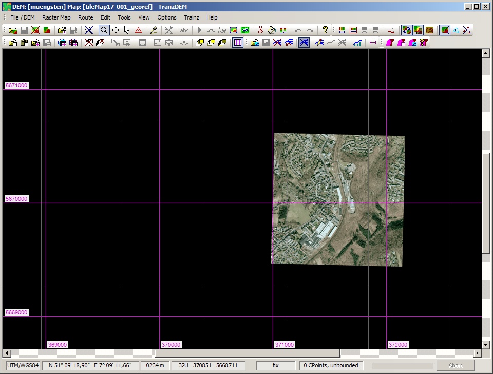
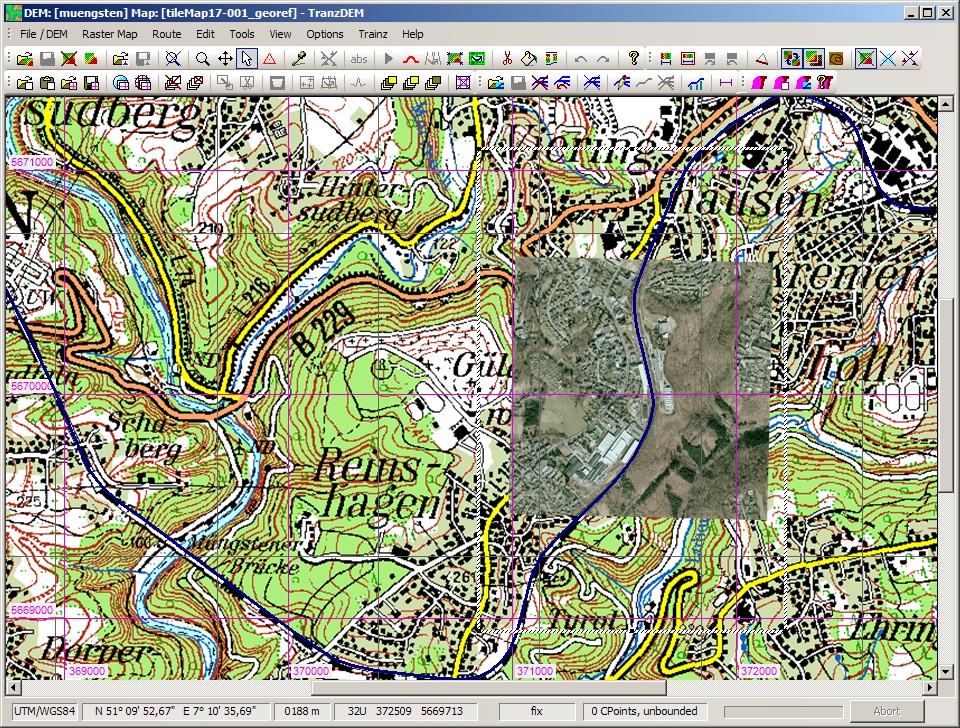
This is an image of the same location as in the TransDEM Trainz Muengsten tutorial (p 46):
Image
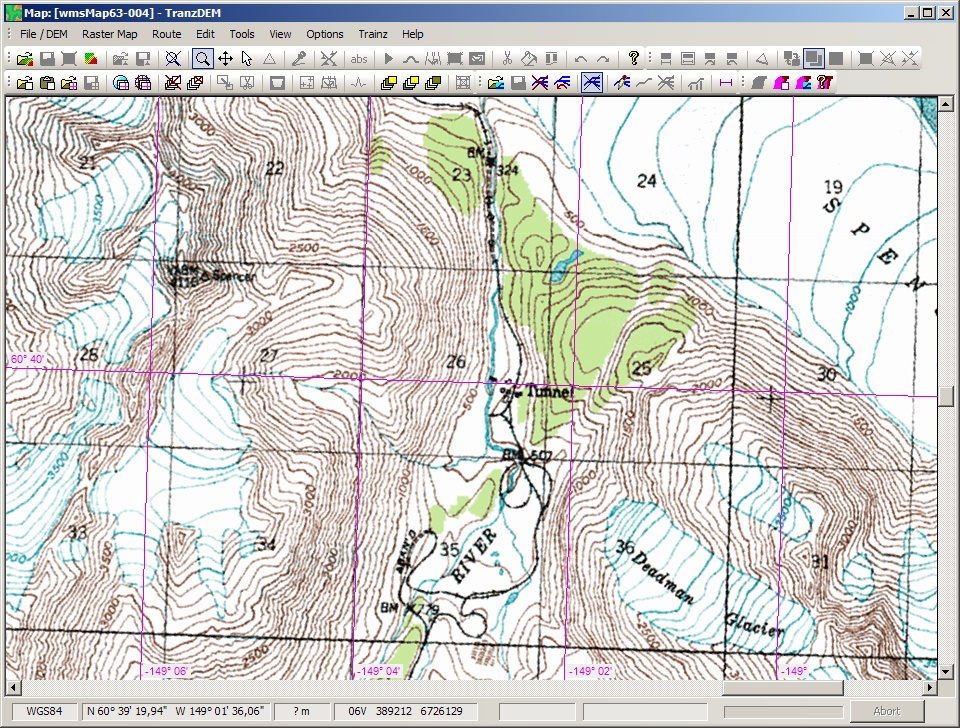
Here, I am using an aerial image on top of the map, not the 1:5,000 topo map as in the tutorial.

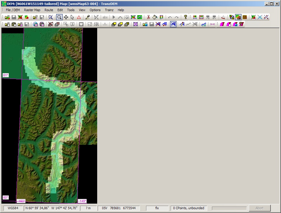
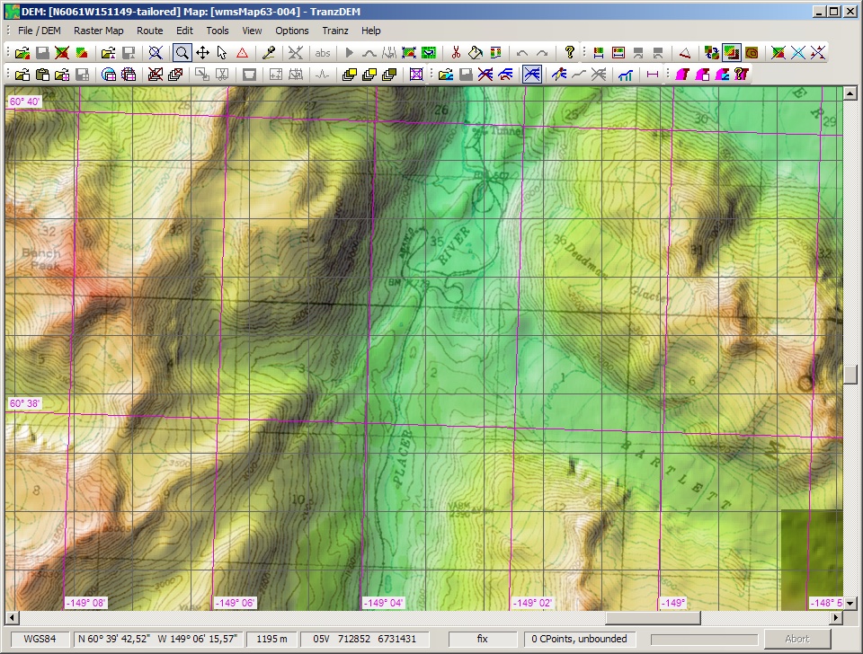
Does your scene look similar? Did you switch on the 1000m raster for the UTM grid (purple). Did you switch on the baseboard grid (dark grey, 720m)? Have you created your rectangular mask as shown to encompass at least one full 1000m UTM square, preferably with the aerial image inside?

liebherr1280 wrote:
First error I get is Inconsistent file names and or missing files for one or more map folders.
This is simply a warning. Some of the directory and file entries in the folder used for data exchange (e.g. C:\Program Files\Auran\TS12\UserData\editing) appear not be Trainz route. As long as you find the route which TransDEM generated in the previous step you should be fine.

liebherr1280 wrote:
For the life of me I have looked 10 times on the tutorials
Did you actually play the Muengsten tutorial from A to Z? With hand-on experience of all the steps? And it worked?

liebherr1280 wrote:
dont know if I am just missing something or not. I just need a little shove in the right direction.
If the scene for your route looks similar to mine, could you post a screenshot? DEM, maps an aerial image loaded, 1000m UTM grid on, 720 m baseboard grid on, rectangular mask placed around aerial image and 1000m UTM square?


Top
 Profile  
 
 Post subject: Re: Google earth issues
PostPosted: 03 Sep 2011 00:29 
Offline

Joined: 02 Sep 2011 20:19
Posts: 11
Geophil
To answer your Questions. The 1000m is switched on the base board tab is checked and I have created a rectangular mask around the square.
As for the tutorials. I was only able to do one of them. The muengsten one worked fine. The other ones did not work. Since there were problems with the URL. Error 404. This happens with every addres I have tried to use off the tutorial. The only difference between that image you have posted and mine is the fact that it is a Google earth image.


Top
 Profile  
 
 Post subject: Re: Google earth issues
PostPosted: 03 Sep 2011 08:02 
Offline

Joined: 05 Jan 2011 16:45
Posts: 1465
Right. So it worked for the Muengsten example. Now, let's try to find out what is missing in your route.


  1. We start with the DEM. This an SRTM DEM, 3 arc sec.
    Image
    What kind of DEM are you using? Where did you download it?
  2. The map. It's for the ground textures of the Trainz route. The map is an 1:50,000 topo map here, acquired via WMS.
    Image
    Which map are you using? How did you acquire it?
  3. The route. A simple vector line to indicate the course of the railroad right-of-way. Hand-drawn for Muengsten
    Image
  4. Optional: One or more aerial images. In this example it's been taken from Map Tile provider "Google Maps", not "Google Earth". This doesn't make any difference for further processing, though.
    Image
    How did you create or acquire vector lines?
  5. In the first step for creating your own Trainz route you would start with combining DEM, map and vector lines and export to Trainz, just as in the Muengsten tutorial.
  6. In an optional second step you would add aerial image(s).
    Here we see map, aerial image, the vector line and the rectangular mask. This is the arrangement of the scene when calling the UTM tile exporter.
    Image
    The DEM is not needed in this second step. The UTM tiles have to go to the very same Trainz route, created in the in the first step, where the DEM had already been used.

    How does your scene look here? A screenshot would be very helpful.


Quote:
Since there were problems with the URL. Error 404. This happens with every addres I have tried to use off the tutorial.
Which URLs exactly did nor work?
Did you import the sample settings provided for WMS and Map Tiles?


Top
 Profile  
 
 Post subject: Re: Google earth issues
PostPosted: 03 Sep 2011 19:50 
Offline

Joined: 02 Sep 2011 20:19
Posts: 11
All the information I have gathered is from Google earth and been created on Transdem. Using the steps in the tutorial. shift o, alt r, shift u and alts. Then closing and reopening trans. then alt O. The reason for me using Google earth is the fact I can not find any good maps or none are available for the location I am trying to replicate. Anchorage, Alaska to Seward Alaska. The first test run was of the Anchorage yard. 1.00km eye elavation and a map width of 1000meters and a height of 700 meters. I will work on getting a screen shot for you. but at this time I do not have a photo sharing program.


Top
 Profile  
 
 Post subject: Re: Google earth issues
PostPosted: 03 Sep 2011 21:27 
Offline

Joined: 05 Jan 2011 16:45
Posts: 1465
liebherr1280 wrote:
I can not find any good maps or none are available for the location I am trying to replicate. Anchorage, Alaska to Seward Alaska.
Well, that's a challenge. Route building in Alaska. Not impossible, though.

TransDEM has many options. There is no "one size fits all" solution to every route project. However, independent of the location of your route, you will always need a DEM and a map first. Ortho-images like Google Earth come last.

The DEM will not be easy. A quick search revealed ASTER GDEMs. This may be an option. Unfortunately we are too far north for SRTM DEMs, at least for Anchorage. At the moment, I suggest to leave the DEM for later.

For a map to produce legible Trainz ground textures, some of the Map Tile provides may offer what you need. Open Street Map shows the railroad, quite detailed as it seems.

To make yourself familiar with Map Tiles, please try the Map Tile tutorial. Map Tile sample settings have been provided as an attachment to my delivery mail. "Tutorial 7: Map Tile Services" starts on page 130 in the TransDEM main manual.

liebherr1280 wrote:
I will work on getting a screen shot for you. but at this time I do not have a photo sharing program.
There are several free image hosting websites. I have used Photobucket in the past.


Top
 Profile  
 
 Post subject: Re: Google earth issues
PostPosted: 03 Sep 2011 22:30 
Offline

Joined: 02 Sep 2011 20:19
Posts: 11
I thank you so much for your help. I Love the route up here in the state. We have a pull that is about 4 miles long and at a 3% grade with a 14 degree curve in it. If you get a change look it up it is called Grandview. I will keep on trying and I will do the tutorial 7 as suggested. I am not giving up hope. Living in Alaska has its disadvanteges. And I guess this one as well.
Thanks again for your help. I will check back soon.


Top
 Profile  
 
 Post subject: Re: Google earth issues
PostPosted: 04 Sep 2011 00:27 
Offline

Joined: 02 Sep 2011 20:19
Posts: 11
Well I am not sure how the heck I did it but some how I ended up getting a Google earth image on Trainz. I have been trying to duplicate it But so far I am having no such luck. The image I do have on is a little smaller then the actual Base. IE have about 6-8 boxes that are black.


Top
 Profile  
 
 Post subject: Re: Google earth issues
PostPosted: 04 Sep 2011 12:11 
Offline

Joined: 05 Jan 2011 16:45
Posts: 1465
How did tutorial 7 go? Did you succeed?

You should also do the Durango & Silverton WMS tutorial since WMS may play an important role for your route, too. (Tutorial 4: Web Mapping Services 2, MSR Maps, USA, on page 113 in the TransDEM main manual.)

Your route is actually quite long, 180km, that's more than 100 miles. I urgently recommend to split into modules, something like 25 mi per module. You will merge in Trainz Surveyor.

Now, your geo data sources:

  • Small scale map: OSM or some other Map Tile provider. If you use OSM, zoom level 10 will already reveal the railroad. Two map clippings at size 1356 pixel each should cover it all. Trace the route.
  • Medium scale map for ground textures: Here I recommend the USGS DRG 1:63,000. Fortunately this is available via WMS: After you completed the Durango and Silverton tutorial, add a new WMS to the USA / Canada folder. Name it "SDMI Alaska Extras" and assign this URL: http://wms.alaskamapped.org/extras?. In layer group "DRG" select layer "DRG 1:63k". Change "Max size" to 1200 x 1200 px. Change scale to 1:80000. This will be good enough.
  • The DEM. This will be ASTER GDEM. Fortunately, the DEM files we need are readily available for download. Register an account at this site (it's free): http://www.alaskamapped.org. Find your DEMs: (Show Available Data | Elevation Data | By Resolution | 30.89m. You will need
    ASTER_GDEM_TIFF.ASTGTM_N60W149
    ASTER_GDEM_TIFF.ASTGTM_N60W150
    ASTER_GDEM_TIFF.ASTGTM_N61W150
    ASTER_GDEM_TIFF.ASTGTM_N61W151 (only a small bit from this one, if at all)
    Open with the grid set to 20m (Preset will be 15m).
    Merge those parts of the DEM you need. If you incorporate N61W151, transform to the adjacent UTM zone, since it will open in zone 5, not 6 as the rest of your route.
    ASTER DEMs may have artefacts, unexpected peaks and holes. TransDEM has editing functions to deal with those artefacts. More tutorials to read.
  • Aerial images. These come last. I would only use them where you need more detail. And I suggest to acquire them from a Map Tile service to take advantage of TransDEM automation functions.

I know it's a lot of stuff. But as I said earlier, route building in Alaska is challenge. You will need to unleash much of the power TransDEM offers. Admittedly, there is a learning curve. But after that you will be able to master it.

Here are some screenshots of what you should obtain (click to enlarge):

Map Tile client: OSM map tiles at zoom level 10, with the route traced:
Image

WMS client: 1:63k, acquired along a path:
Image

The level of detail you can expect from the 1:63k topo map:
Image

The ASTER DEMs, tailored for the route:
Image

Same spot as before, DEM and topo map
Image


Top
 Profile  
 
 Post subject: Re: Google earth issues
PostPosted: 04 Sep 2011 16:25 
Offline

Joined: 02 Sep 2011 20:19
Posts: 11
That was awsome. Well I will give the tutorial a try when I get back home in 2 weeks. I work remote so I will be gone for a bit. I will drop you a line with any questions. I showed the wife what you had done and she said I should just purchase the information from you. I did have one more question I understood most of everything that you put down except for one Item............. In layer group "DRG" select layer "DRG 1:63k". Change "Max size" to 1200 x 1200 px. Change scale to 1:80000. This will be good enough.
Is this in the Web mapping services drop down in order to get the map? Thank you again you have been a huge help. And have saved me many more headaches. I will keep working on it. I know I can do it. Just need a shove in the right direction.


Top
 Profile  
 
Display posts from previous:  Sort by  
Post new topic Reply to topic  [ 20 posts ]  Go to page 1, 2  Next

All times are UTC + 1 hour


Who is online

Users browsing this forum: SemrushBot [Bot] and 27 guests


You cannot post new topics in this forum
You cannot reply to topics in this forum
You cannot edit your posts in this forum
You cannot delete your posts in this forum

Search for:
Jump to:  

Imprint & Privacy

Powered by phpBB® Forum Software © phpBB Group