Requires TransDEM 2.1.2 or higher.British Ordnance Survey offers a variety of map data with their Open Data initiative:
http://www.ordnancesurvey.co.uk/oswebsite/opendata/Among them is
OS VectorMap™ District, a vector map at a nominal scale of 1:25000. We will abbreviate it to VMD.
Data is packed into tiles of 10 x 10 km and structured by O/S 100 x 100 km grid squares. To find the grid square, an overview map should be loaded in TransDEM and the coordinate system switched to OSGB36. Grid square codes are shown in the TransDEM status bar, if the
View | Show grid square option is activated. The numerical digits in the file name indicate the 10 km tile in square coordinates, the first digit for the easting, the second digit for the northing.
The following is an example on processing this data. We will look at an area in the Pennines, Lancashire and West Yorkshire, which I have used before. It's the home of the Rochdale and the Leeds & Liverpool canals. We will find railways, too, but I may be a bit distracted here, when dealing with this part of England.
- We start with the DEM and picked O/S Land-form Panorama square SD82 for this.
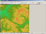
Note the TransDEM status bar: Coordinate system set to OSGB36, Grid square display on: "SD".
What we look at are the River Calder valleys, Todmorden in the south east, Burnley in the north west.
- Download the VMD map in vector format (ESRI Shape) for the SD square and unpack.
- As the grid size for VMD is 10 km we will need four squares to fill this DEM, actually only three as we will concentrate on the railway which will not be present in the north east quadrant.
We start with SD82 for the south west quadrant. You will find it in your folder where you unpacked the data:
....\vmdvec_sd\OS VectorMap District (Vector) SD\data\SD\SD82
There are a number of layers. We will confine on railways and polylines. This layer is named "Railway_Line".
In TransDEM click Route | Open Route... and change the format to ESRI Shape.
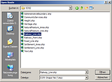
Select Railway_Line.shp and click OK.
- TransDEM will pop-up a confirmation box to convert coordinates. VMD data is in ESRI shape format, however, coordinates are non-standard OSGB36. The shape format has no means to carry such non-standard information in its files. Therefore it is important to have switched to OSGB36 coordinates in TransDEM before opening the file, see above.

Click "Yes" in this box.
- TransDEM will read the vectors and display them:
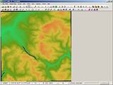
The data is now in UTM/WGS84 coordinates, converted from OSGB36. Because of the conversion TransDEM treats this data as edited and requires you to save the data to retain the conversion.
Click on Route | Save Route... . Choose the format you like. Default .str will be fine.
- Repeat loading for squares SD92 and SD83 and Railway_Line.shp in those folders. Reply "yes" to the conversion question and then save each file.
When all three files have been loaded and individually saved, your picture will like this:
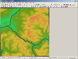
- Now, save once again, this time select Route | Save Route as... . This will combine the three route files loaded to a single file, convenient for future use.
- That's it.
Looking closer at the vector data we notice a number of gaps:
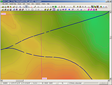
At first glance it looks like a quality issue, but it is not. The purpose of this vectors is to provide the data for drawing a map, not for navigating track.
Adding an ortho image reveals the nature of the gaps: overbridges.
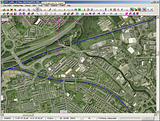
Quite helpful, when working on the route in Trainz Surveyor later.
The picture also shows the Leeds & Liverpool Canal meandering on its way through Burnley with the modern times motorway aqueduct at the top edge. At the other end of town you would find the Burnley Embankment, one the engineering marvels of the Canal Age.


