TransDEM 2.3 is available.
Version 2.3 brings new map processing capabilities and adds support for GPS devices.
The new features in brief:
- Georeferencing option using Triangulated Irregular Networks for distorted maps and plans.
- Option to save pre-processed raster image (cropping, resolution) as a file before georeferencing.
- Support for MicroDEM format version 3.
- Enhanced GeoTIFF export option for DEMs with support for geographic coordinates.
- Live track log option for GPS devices.
- Export option for georeferenced raster maps as a .kmz package for some Garmin® GPS models.
- Documentation: New tutorial for TIN georeferencing.
- Documentation: New tutorial for USGS National Map WMS.
What is TransDEM about?
TransDEM Trainz Edition is a helper tool for building prototypical routes in Trainz. It processes geo-data, in particular DEMs (Digital Elevation Model = height data) and cartographic map images and creates Trainz terrain from it.
New Users: How much does it cost?
TransDEM Trainz Edition is Payware. The fee for a personal non-commercial license is €22.90 including PayPal fees.
(This is about GBP 19.50, USD 31.00, CAD 31.00, AUD 30.00, NZD 38.00 or JPY 2500, including PayPal fees. Currency conversion rates as of 26 Nov 2012)
New Users: How can it be ordered?
You can order TransDEM or request more information with a simple email: info@rolandziegler.de. I will send you an info letter with further details of the purchasing and downloading process.
Current Users: Update Policy
There will be a free update for current TransDEM users who purchased their license within the last 12 months. These users should receive an email from me with further details within the next two weeks.
All other users can obtain an upgrade license for a fee of €7.90, including PayPal charges. Please email me at info@rolandziegler.de if you are interested, including enough information to find you in my database: your full name and original order ID.
Resources
Updated TransDEM configuration samples for WMS and map tiles can be downloaded here (without any warranty!). Some servers will only work with TransDEM 2.2 or higher!
What kind of features does TransDEM offer?
Geo-Data: Digital Elevation Models (DEMs)
- Direct support for SRTM, USGS NED and ASTER GDEM (version 1 and 2, GeoTIFF), Canadian CDED DEMs, ESRI Grid and ESRI BIL including projected coordinate systems, plus MicroDEM format for a lot of other DEM types. (SRTM support includes US 1 arc sec data and “Viewfinder-Panorama” 1 and 3 arc sec DEMs.)
- DEM Editing capabilities: adjustment of elevations (Triangulated Irregular Network algorithm - TIN), hole filling, smoothing, clipping, re-sampling, horizontal and vertical shifting, plus contour tracing for DEM refinement.
- DEM shading, DEM based contour lines to ease to enhance DEM visualisation.
Geo-Data: Raster Maps, Orthophotos
- Georeferencing of topographic raster maps with coordinates, dedicated functions for easy-handling of this often error-prone task.
- Easy-handling of maps from on-line geo-servers (conventional browser interface).
- Automatic georeferencing of GeoTIFF images.
- Function to create transparent margins to avoid occlusion with overlapping maps and plans.
- WMS client (“Web Mapping Services”) for automating the cartographic map image acquisition. Compatible servers exist in several countries, e.g. USA, Canada, Norway.
- Map Tile client, similar to WMS client, for raster maps in Mercator projection and organised as a quadtree structure, as offered by certain Web servers. Examples are the (road-)map and orthophoto services by Google, Microsoft or Open Street Map.
- Semi-automatic georeferencing of Google Earth™ images, using “placemarks”.
- Support for UTM, geographic coordinates (lat/long) and a number of national coordinate systems in use in North America, Europe, Australia and New Zealand.
Geo-Data: Vector Data
- Vector overlays and polyline editor, read and write support for various file formats, shp, dxf, kml/kmz and others.
- Data exchange with GPS devices via .gpx data.
- Import conversion for data in national coordinate systems.
Trainz Map Creation
- Direct creation of all files making a Trainz route map.
- Fully compatible with TRS2004, TRS2006 family (including TRS2007 and Trainz Classics), TS2009 (SP2), TS2010 (SP3) and TS12 (SP1).
- Baseboard alignment with the UTM grid. Allows for a modular route building approach.
- DEM shaped terrain.
- Ground texture and minimap based on raster map (limited resolution). Optional 5m grid for TS2009 and above.
- Support for custom ground texture set, including removal.
- Automatic placement of UTM tiles (texture carrier objects with higher raster map or orthophoto resolution), 1000m and 500m
- Direct creation of Trainz spline objects from 2D and 3D vector data, allows to “lay track” in TransDEM.
- Usage of the Trainz World Origin object for maintaining an absolute coordinate reference which allows adding of UTM tiles or spline objects at a later stage.
- Lowering or raising a conventionally built Trainz route to merge it it with a DEM based route.
- Optional horizontal baseboard grid offset for TransDEM-generated terrain to achieve better matching with existing conventionally-built Trainz route modules.
Support for GPS devices
- Import: Live track log option for GPS devices via NMEA1083 protocol to record GPS positions as vector data, COM or USB (USB needs 3rd party converter).
- Export: Option to save georeferenced raster maps as a .kmz package with geographic coordinates and automatic tiling for Garmin® GPS devices (and Google Earth™).
Documentation
TransDEM comes with extensive English documentation in pdf format, about 260 pages in two manuals. Tutorials make up a major part. They cover various aspects of TransDEM's capabilities including the mainstream functions of generating terrain for Trainz quickly.
Example: US route with USGS geo data
USGS geo data is a well established, high quality and easy to use source for US Trainz routes with TransDEM.
Now, in 2012 both the sources for DEMs and topo maps have changed. Seamless server has been replaced by The National Map Viewer and MS Research Map WMS with The National Map WMS
The data, however, is still the same.
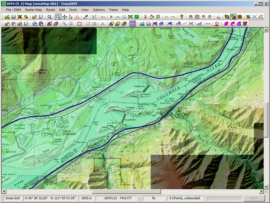
Here is a typical example, Bonneville Dam, Columbia River, Oregon/Washington.
1/9 and 1/3 arc sec NED DEM with 1:24k DRG scanned topo map:
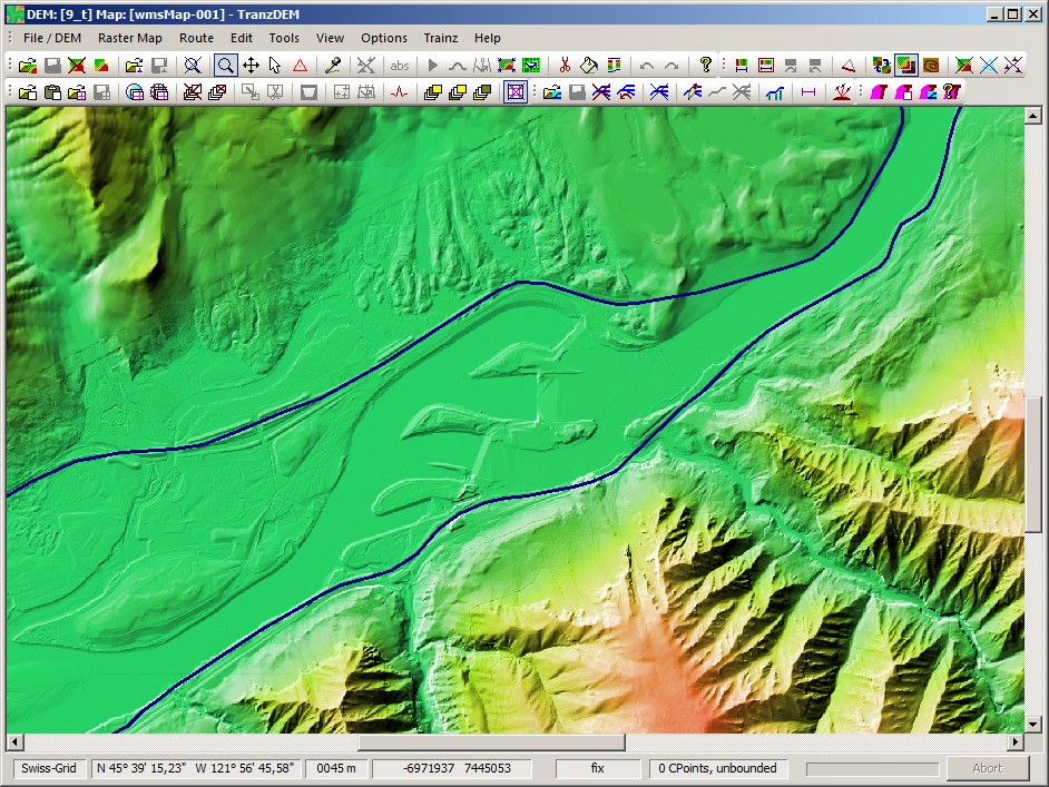
Without the topo map, cuttings/high fills and other man-made structures modelled in the 1/9 and 1/3 arc sec DEMs stick out more clearly:
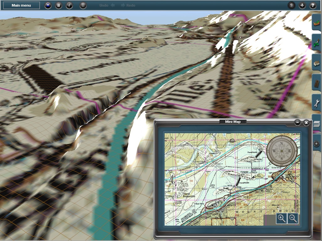
In the Trainz route, the topo map ground texture nicely matches the DEM shaped terrain.
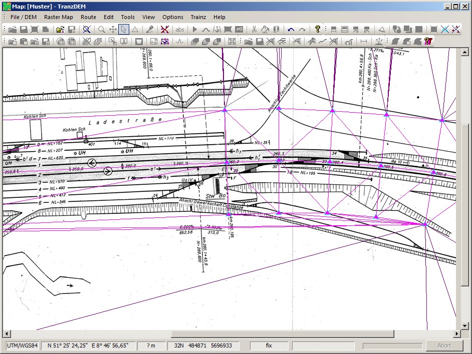
Example: Georeferencing a distorted track plan
The new TIN-based georeferenced option allows handling of distorted maps and plans. In this examples, the axis perpendicular to the track centreline is stretched by a factor 3:1. Using TIN control points, the user is able to eliminate or significantly reduce the distortion. (It remains a somewhat challenging task, though)
Band of georeferencing control points:
Georeferenced and cropped result, placed on top of ortho-images:

Example: GPS track log
The research phase before actually building a Trainz route may include some outdoor activity. GPS plays a helpful role when surveying your own railway, particularly if there is no good map available.
The new GPS track log function may make it easier to find your bearings in the field, using something like a netbook with a relatively large screen, running TransDEM and connecting a GPS to it.
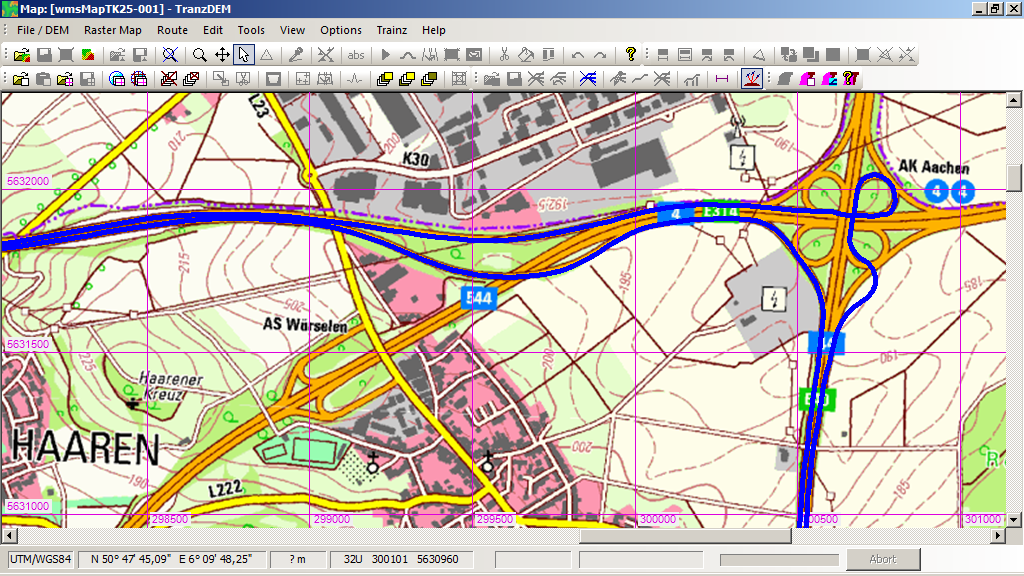
This is sample of a GPS tracklog with TransDEM, driving on a motorway. GPS device is a Garmin GPSmap® 60CSx.
Example: Raster map KMZ export for Garmin®
Sometimes it is useful the other way round. Take raster maps, georeferenced in TransDEM and export them to a recent Garmin® GPS model with mapping support.
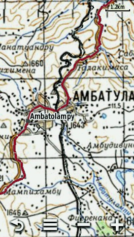
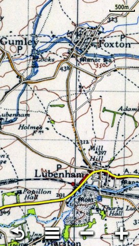
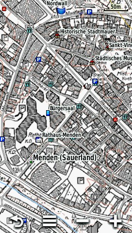
Three KMZ export examples as screenshots taken on a Garmin Montana™:
- Soviet military map 1:200,000 for Madagascar, combined with Open Street Map vector data. The Soviet map is still quite accurate and has more details than OSM. The railway line in OSM didn't even exist until our railway enthusiasts' trip in early 2012.
- Historic UK O/S 1:50,000 topo map of Foxton Locks at the Grand Union Canal, Leicester Section. Vector data by Garmin Recreational Map Europe.
- 1:5,000 topo map of Menden, a small town in Sauerland, Germany. Vector data by Garmin Recreational Map Europe.
Roland Ziegler (geophil)