TransDEM Forum
https://forum.transdem.de/

Issue with maps
https://forum.transdem.de/viewtopic.php?f=2&t=676
Page 2 of 2

Author:  SAR704 [ 02 Sep 2023 03:52 ]
Post subject:  Re: Issue with maps

I've only been using the program for a month and a bit. So a lot still to pick up on.

Anyhow, may I ask what this refers to in the post you linked to?

I am not sure whether or not you mean UTM, and raster in the lines below from the post.


Quote:
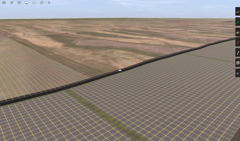
The DEM data is 1/9 arc sec. For this reason I created 3D UM tiles with 5 m resolution - which takes ages to produce. I also selected the "Draw Grid" option to get the 10 grid lines.

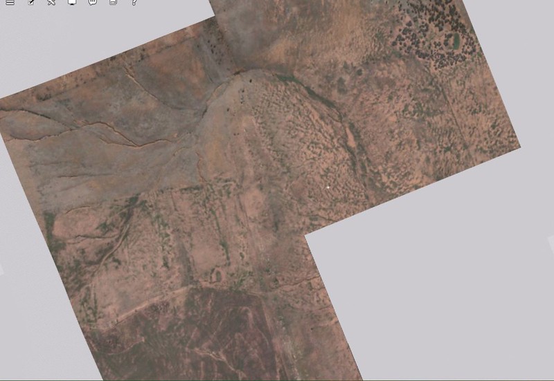
This is the rater small "layout", about 70 sq km:


How do you create 5M resolution tiles in TransDEM? And how did you get them to stick to the terrain like glue in the image shown in your post?

I'm also curious. How wide should a baseboard be in TRS19 for distant scenery?

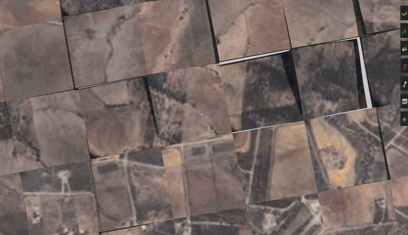
And my memory isn't exactly flawless. How would this kind of overlay be theoretically created? The one I tried for the mainline that this tacks onto is a mess in comparison, and consists of poorly aligned rectangles, with huge gaps, and nothing once one gets at about 1km into the route further east. The mainline is the troublesome one. This is something from a week ago, not today. Is there a way to open a text file or something to check which settings one used with TransDEM?

Image

Edit: Also, is there a way to automate the scenery folder being named 'Scenery' with a capital S instead with the create new map option? i am so tired of lower case letters being the norm with new lines commencing. it gets so annoying.

And this is what the DEM set up looks like in the program. There are a few parameters I'm unsure of. Are there inappropriate values shown?

Imagehttps://flic.kr/p/2oZD5xS

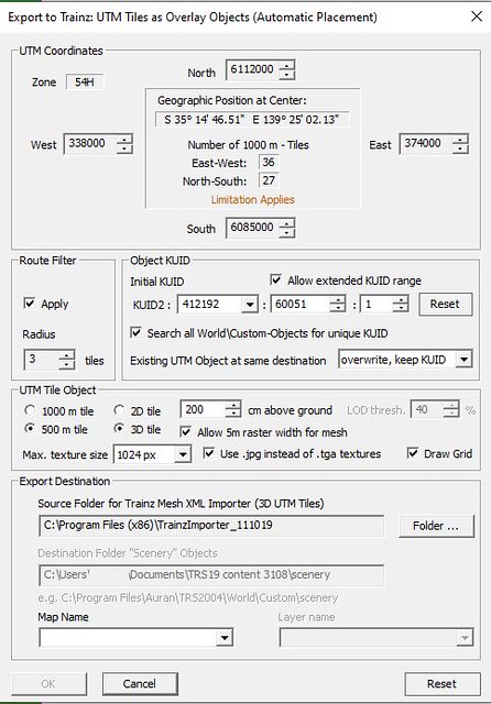
This is what the UTM export window shows.

Image[url=https://flic.kr/p/2oZDs8d]

The 'map name' field is blank, because I've been exporting to a folder separate from the default one, due to ongoing errors, and I moved the export folder to the main folder after exporting.

Author:  SAR704 [ 03 Sep 2023 08:33 ]
Post subject:  Re: Issue with maps

And also, I just happened to read the manual, and noticed a mention which I don't recall noticing in any of the tutorials. Pressing F9 enables the ground to become transparent, with the UTM tiles showing. But I notice that they are all mismatched in this scenario. Can't make sense of it.

ImageS17

Author:  geophil [ 03 Sep 2023 13:42 ]
Post subject:  Re: Issue with maps

Did you succeed with the Muengsten tutorial? With all its steps? If yes, why not simply adding a few more ortho-images to it and see if that works, too? And then do W. Flint's video. tutorial.

Author:  SAR704 [ 03 Sep 2023 14:20 ]
Post subject:  Re: Issue with maps

Actually, I think I've started to figure out more of where I was stuffing up. Turns out I have read the tutorial you mentioned, earlier on. I had some UTMs mixed up with ones from another project. But can't figure out exactly how. Nonetheless, the folder's been emptied now in readiness for new exports.

And this is very trivial. But is there a way in TransDEM to adjust the name of the scenery folder, which comes up in the 'Create new map' option at the top right of the interface? The lower case 'scenery' export annoys me, and I'd like to adjust it to an upper case character. The folders look awful otherwise.

Author:  geophil [ 03 Sep 2023 14:43 ]
Post subject:  Re: Issue with maps

Quote:
But is there a way in TransDEM to adjust the name of the scenery folder
That's the name used by Trainz itself, at least in earlier versions, for exporting data. So I kept it. Clear or rename it to your liking when making a new route. However, unless you reset the KUIDs or mess around with the cache, they should be unique.

Author:  SAR704 [ 03 Sep 2023 20:52 ]
Post subject:  Re: Issue with maps

Well, what I'd also like to ask is how to expand this UTM overlay. The resolution seems to be ok. But it's far too narrow to be of any help. The zoom level with the map tile servers section is set at 16.

Can this type of UTM overlay be expanded in this resolution to be at least 3kms wide?

ImageS16

Edit: It took me 20 minutes to get the image embedded, due to not realising the 'disable BBCode' was ticked. I think an option to attach images up to at least 800 x 600 pixels would be quite helpful, especially given the website I'm using has an upload limit.

Author:  geophil [ 04 Sep 2023 19:47 ]
Post subject:  Re: Issue with maps

SAR704 wrote:
Well, what I'd also like to ask is how to expand this UTM overlay. The resolution seems to be ok. But it's far too narrow to be of any help. The zoom level with the map tile servers section is set at 16.

Can this type of UTM overlay be expanded in this resolution to be at least 3kms wide?
Enable "Route filter", and set "Radius". Needs a route to be loaded, of course. I'm not sure about zoom level 16 for ortho-imagery, though. Users typically go for 18 or 19, provided the data source is sharp enough for that. And ground texture form Open Street Map at zoom level 15 for a 5m baseboard grid.

Author:  SAR704 [ 21 Oct 2023 04:16 ]
Post subject:  Re: Issue with maps

There is another issue with the UTMs, which is annoying. For some reason, the adjoining tiles render a very low resolution, which makes it impractical to attempt to place track on top of.

There are 4 UTM tiles shown (with more out of view). 3 of them show up at very low resolution, with one being an more ideal resolution.

I have tried various settings with TransDEM (latest version). I have noticed a few images south of the only relatively clear image being visible. Using the 500M 2D tile with 4096 resolution. What am I doing wrong here? The UTMs look clear in TransDEM, but not the game. I just want the UTMs to render at a decent resolution, instead of the current pathetic one.

Image

Author:  geophil [ 22 Oct 2023 08:49 ]
Post subject:  Re: Issue with maps

SAR704 wrote:
There is another issue with the UTMs, which is annoying. For some reason, the adjoining tiles render a very low resolution, which makes it impractical to attempt to place track on top of.
TransDEM can only export to UTM tiles what you loaded before. Make sure that you acquire your ortho imagery at the right resolution for your entire export area. If I interpret your screenshot correctly and the faint white grid shows UTM tile borders, then resolution changes inside the tile, a clear indication to different resolution in your source data.

Page 2 of 2 All times are UTC + 1 hour
Powered by phpBB® Forum Software © phpBB Group
http://www.phpbb.com/