
I think thats the junctions sorted. Still have to load it up in Surveyor and double check. Given what Ive been told regarding expanding a route later, I think Ill have a go at building just the fremantle NQRT to Kewdale-Forrestfield section for now.
| TransDEM Forum https://forum.transdem.de/ |
|
| Some screenshots of TransDEM https://forum.transdem.de/viewtopic.php?f=2&t=453 |
Page 2 of 2 |
| Author: | geophil [ 30 Aug 2016 19:00 ] |
| Post subject: | Re: Some screenshots of TransDEM |
Blu3wolf wrote: So far its all Zone 50 - some of it 50H, some of it 50J. I guess thats not an issue. No, latitude does not matter, as explained in my other posting yesterday. However, you can't cross the equator. Not a problem for Australia, but you wouldn't be able recreate the Uganda Railway with TransDEM at the moment. It'll work from Mombasa to Lake Victoria, which is still southern hemisphere, but not further onward. Until now, no one has attempted to build that line in Trainz but if someone did, I would have another look how this could be supported. Blu3wolf wrote: If I want to export a non rectangular route to Trainz, but I want to select specific areas to do so, is there a way to select multiple areas, using add/subtract from the rectangular mask tool? You can and should use the polyline editor to draw a coarse centre line which will serve as export filter. The lateral extent can defined by the number of baseboards to either side, in the export dialog. It's similar to the "along a path" filter in the map tile client.
|
|
| Author: | Blu3wolf [ 31 Aug 2016 12:31 ] |
| Post subject: | Re: Some screenshots of TransDEM |
Exported it into Surveyor to check it out... the track will need some work still. Its actually created junctions automatically in a few places, which I wasnt expecting it to do. I guess to do it automatically, the polylines need be close together and reasonably aligned? I guess I can go through and mess with each junction, but I have a LOT of those across the various yards. I guess I also should look into whether decent DG track assets exist on the DLS. I do need DG track, for part of Forrestfield, and for part of the line to Fremantle - as well as a lot of Kwinana if I do the southern expansion, and a good portion of the northern line, if I do that. I dont really want to just make everything SG, because most of the state is NG, and any decent assets for WA trains is going to reflect that. Ideally I guess there would be a decent DG asset and corresponding NG42 to go with it, that goes nicely with a set of SG track as well. http://images.blu3wolf.com/uploads/export.PNG http://images.blu3wolf.com/uploads/exportmaptest.PNG If I model the different gauges, Ill need to create multiple sets of vector data, but I can do that relatively easily by copying the existing set, then deleting portions from it that do not match the selected gauge, with reference to GE data. I guess I need to go back over it anyway, to tidy up the track around junctions. Otherwise, I model a similar layout assuming its all SG - not a big deal for the yards, just the mainline - the selected yards are almost entirely SG anyway, although Kwinana is not, and the CBH terminal at Forrestfield is also NG. |
|
| Author: | geophil [ 31 Aug 2016 14:02 ] |
| Post subject: | Re: Some screenshots of TransDEM |
Blu3wolf wrote: Its actually created junctions automatically in a few places, which I wasnt expecting it to do. I guess to do it automatically, the polylines need be close together and reasonably aligned? Yes. There is also a context menu function in the polyline editor, "Snap point to nearest", to assist you here.
|
|
| Author: | Blu3wolf [ 01 Sep 2016 16:17 ] |
| Post subject: | Re: Some screenshots of TransDEM |
I have learnt a new valuable TransDEM lesson tonight. Undo states are NOT saved if you close the Simple Route Editor. This I know, now. |
|
| Author: | Blu3wolf [ 05 Sep 2016 15:41 ] |
| Post subject: | Re: Some screenshots of TransDEM |
I think thats the junctions sorted. Still have to load it up in Surveyor and double check. Given what Ive been told regarding expanding a route later, I think Ill have a go at building just the fremantle NQRT to Kewdale-Forrestfield section for now. |
|
| Author: | Blu3wolf [ 06 Sep 2016 15:34 ] |
| Post subject: | Re: Some screenshots of TransDEM |
 Nearly a gigabyte worth of DEM there... should be able to get some of the hills in at least. Spent this evening messing around with DG track, although so far its looking suspiciously like this might need to be SG to start with. |
|
| Author: | Blu3wolf [ 08 Sep 2016 11:08 ] |
| Post subject: | Re: Some screenshots of TransDEM |
And this has been the result of TransDEM's output: 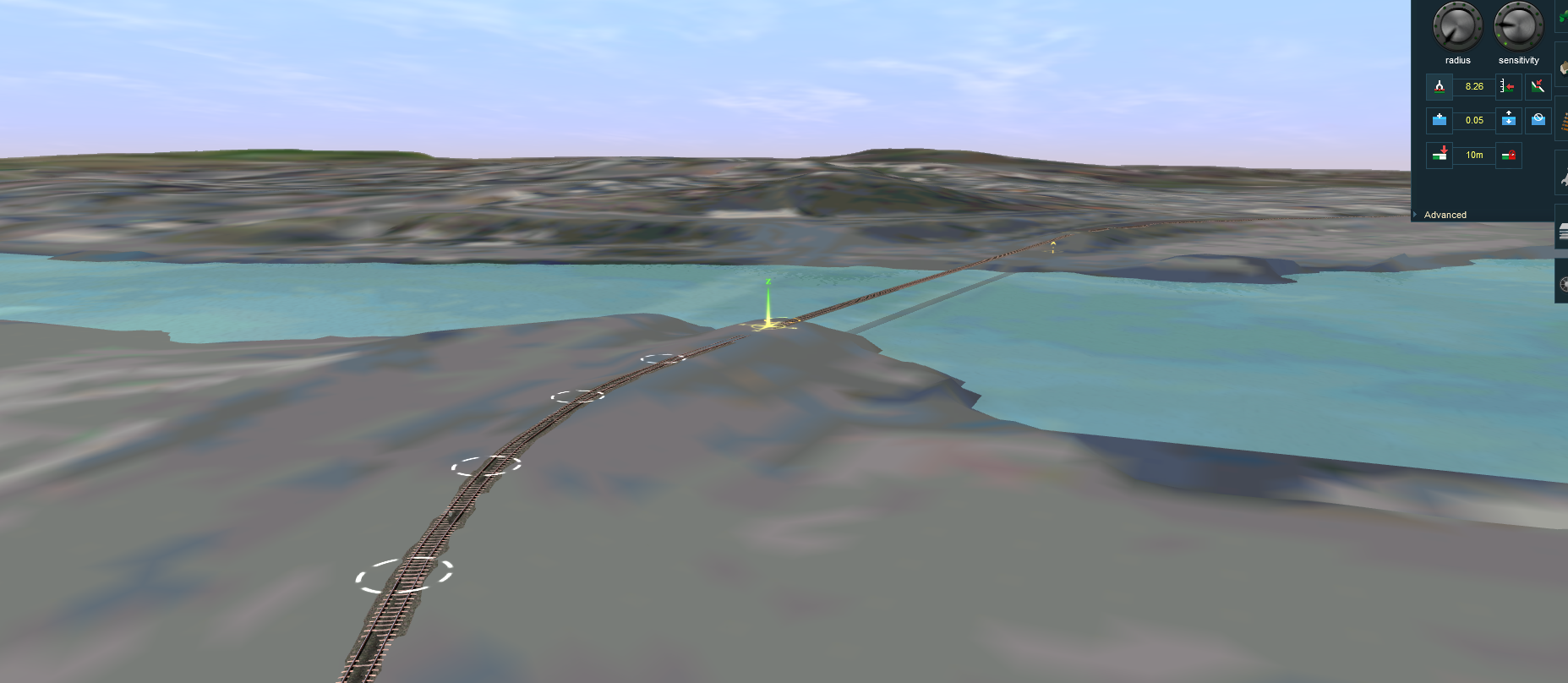 Still plenty of work to do, but I guess for the next lot of hard work, I wont need TransDEM for it. Which is a shame, as its a much easier tool to use than Surveyor :/ |
|
| Author: | geophil [ 08 Sep 2016 21:14 ] |
| Post subject: | Re: Some screenshots of TransDEM |
Orthoimages as ground textures will always come out blurred. Resolution is just too low. I recommend to use some sort of map instead to generate ground textures and then afterwards let TransDEM produce UTM tiles as texture carrier objects for the imagery. |
|
| Author: | Blu3wolf [ 09 Sep 2016 01:52 ] |
| Post subject: | Re: Some screenshots of TransDEM |
OSM is a little sparse for detail Im afraid, and I dont have much in the way of other options. Its basically urband environment for the whole route anyway, through south Perth. |
|
| Page 2 of 2 | All times are UTC + 1 hour |
| Powered by phpBB® Forum Software © phpBB Group http://www.phpbb.com/ |
|