I've been looking at the Transdem help files and my head is starting to spin!
Can somebody point to the information that is needed to work with these 3D UTM Tiles?
| TransDEM Forum https://forum.transdem.de/ |
|
| Topographic Questions https://forum.transdem.de/viewtopic.php?f=2&t=357 |
Page 1 of 2 |
| Author: | BlackDiamond1964 [ 20 May 2015 18:04 ] |
| Post subject: | Topographic Questions |
I ran my new project through Transdem, I used a topographic overlay from maps from around 1969. All worked well but I noticed that when I go to the building level in TANE, the overlay of the map is not very clear. I did import the raster mapping overlay at their highest setting. http://hostthenpost.org/uploads/5f9b689024e7baf625c1570978163dc0.png I say this because I've seen other Transdem maps that are far clearer then the one shown here. Am I doing something wrong? |
|
| Author: | Jerker [ 21 May 2015 01:53 ] |
| Post subject: | Re: Topographic Questions |
G'day BlackDiamond1964, ...that which you have there, Sire, is about 'normal' for Topographic maps used as Terrain textures, given the abominable 10 meter resolution of the Trainz baseboards. Some improvement can be obtained by using the 5 meter grid (with a subsequent performance penalty) but the end result still "leaves a lot to be desired". The only way to improve on this is to export this terrain map with additional 3D UTM Tiles, which will reproduce the quality of your original Topographic map in the actual resolution of the *.png/*.gif file in use. It is undoubtedly these tiles, used with a route export, that you have seen showing the 'better' resolution. The instructions for accomplishing this task can be found in the excellent tutorials provided with the program... Jerker {:)} |
|
| Author: | BlackDiamond1964 [ 21 May 2015 04:18 ] |
| Post subject: | Re: Topographic Questions |
Thank you Jerker, I will look into your suggestions. |
|
| Author: | BlackDiamond1964 [ 21 May 2015 05:33 ] |
| Post subject: | Re: Topographic Questions |
I've been looking at the Transdem help files and my head is starting to spin! Can somebody point to the information that is needed to work with these 3D UTM Tiles? |
|
| Author: | geophil [ 21 May 2015 08:32 ] |
| Post subject: | Re: Topographic Questions |
BlackDiamond1964 wrote: I ran my new project through Transdem, I used a topographic overlay from maps from around 1969. All worked well but I noticed that when I go to the building level in TANE, the overlay of the map is not very clear. Jerker already pointed out the 5m option. For technical reasons, the way Trainz implemented ground textures, map texturing is limited to 1 pixel per ground vertex. That produces reasonable results for up to 1:50,000 with the 10m grid and up to 1:24,000/1:25,000 with the 5m grid. Any larger scale and particularly aerial photography: UTM tiles.
|
|
| Author: | BlackDiamond1964 [ 21 May 2015 17:10 ] |
| Post subject: | Re: Topographic Questions |
Ok thanks...I needed to find the starting point with in all the help file topics. |
|
| Author: | BlackDiamond1964 [ 24 May 2015 05:39 ] |
| Post subject: | Re: Topographic Questions |
In my first attempt at adding the 3D UTM tiles, I got this...  What am I doing wrong? |
|
| Author: | geophil [ 24 May 2015 07:48 ] |
| Post subject: | Re: Topographic Questions |
BlackDiamond1964 wrote: In my first attempt at adding the 3D UTM tiles, I got this... You did do the "Muengsten" tutorial?Quote: What am I doing wrong? From your screenshot it appears you do not have a coordinate system set. I'm not absolutely sure but try to set it to UTM/WGS84 and also activate the 1000 m grid option.
|
|
| Author: | BlackDiamond1964 [ 24 May 2015 18:36 ] |
| Post subject: | Re: Topographic Questions |
Just before I was about to give up on the process I got it to work...but I'm still not sure what I was doing wrong. My next question... Is there a way to make the 3D UTM tiles without using the 2D overlay? |
|
| Author: | geophil [ 24 May 2015 20:55 ] |
| Post subject: | Re: Topographic Questions |
BlackDiamond1964 wrote: My next question... Is there a way to make the 3D UTM tiles without using the 2D overlay? Yes, you can export bare terrain. You can also export plain orthoimagery as ground textures, if you use the orthoimage texture set, without any grid lines. That might save some time for texturing the more remote baseboard. But beware of copyright issues with ortho-images. Landsat 7 should be okay, since it's public domain, but resolution is low, only suitable for backdrops. Example (foreground 3D UTM tiles with 1:5,000 topo map, background orthoimage ground texture overlay): 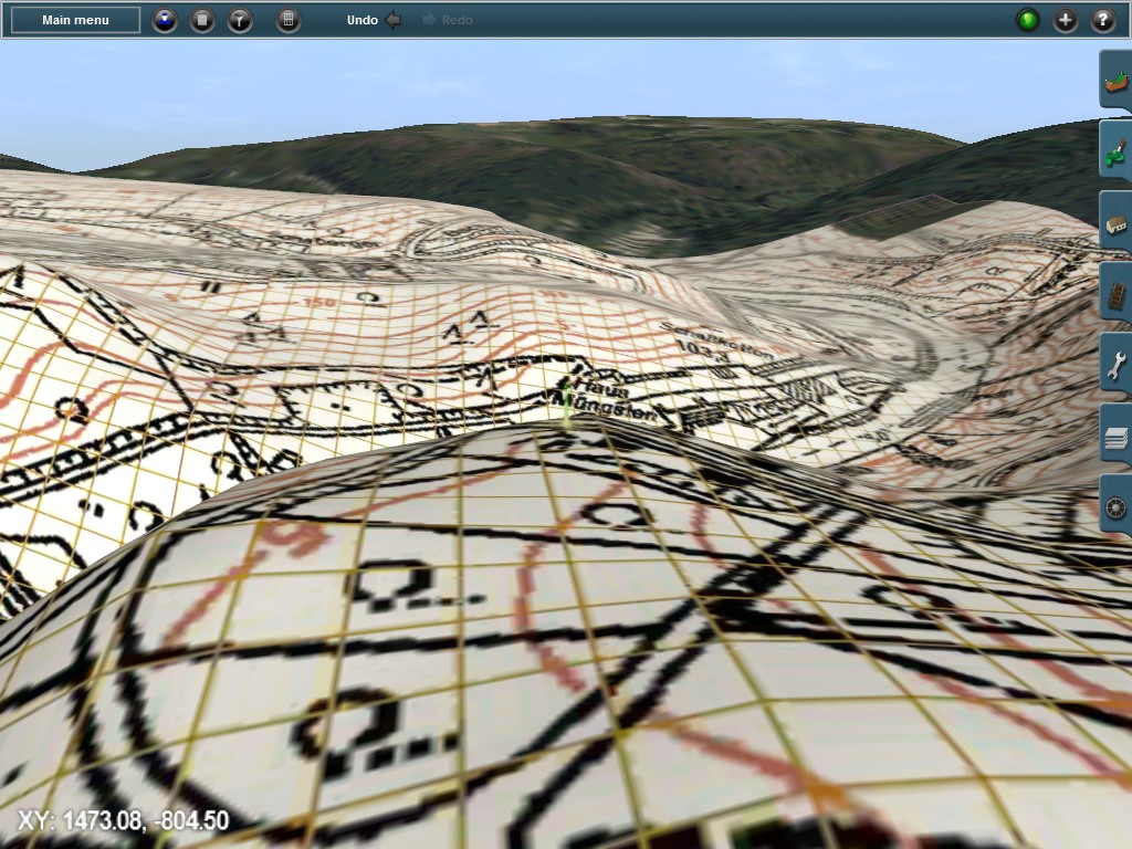 3D UTM tiles take the terrain from the Trainz route, not from any DEM loaded in TransDEM, but for the overlay they deploy what's currently visible in TransDEM. |
|
| Page 1 of 2 | All times are UTC + 1 hour |
| Powered by phpBB® Forum Software © phpBB Group http://www.phpbb.com/ |
|